Cultural heritage site selection characteristics and the impact of the natural environment in Jinan city, China
December 27, 2024
Abstract
This study aims to explore the spatial distribution and site selection characteristics of cultural heritage sites, as well as the impact of the natural environment on the site’s location. A total of 448 cultural heritage sites in Jinan City (Shandong province), which have been listed as key cultural relic protection units from before the Qin Dynasty to after the Qing Dynasty (ca. 7500 BCE–present), were analyzed using spatial analysis tools in ArcGIS 10.6 software. The main research findings are as follows: (1) cultural heritage sites have a wide distribution and few cores and are characterized by spatial agglomeration and the formation of a single core area around the Lixia District; (2) in terms of spatiotemporal evolution, cultural heritage sites follow a “diffusion–aggregation–diffusion–aggregation� trend, exhibiting a “southwest–northeast–northwest� trajectory, with characteristics of continuity and a centripetal pattern; and (3) cultural heritage sites are mainly distributed in alluvial plains with heights ranging from 2.6–100 m, slopes ranging from 0–5°, and distances ≤ 1 km from water systems. The more recent the construction year of the cultural heritage site is to modern times, the more closely its type is to production and living, and the more relevant it is to the natural environment.
Introduction
Cultural heritage serves as a representative and carrier of cultural inheritance, and a symbol of historical memory in a specific space1. UNESCO defines cultural heritage as including artifacts, monuments, groups of buildings and sites, and museums that have a diversity of values including symbolic, historic, artistic, aesthetic, ethnological or anthropological, scientific, and social significance. Currently, the importance of cultural heritage for various countries is increasingly prominent, which is reflected not only in general economic and cultural perspectives but also in national values and cultural views2. Jinan, located in Shandong Province part of China, with its rich cultural heritage, has been designated a historical and cultural city by the State Council of China. In 2018, Jinan began mapping for architectural heritage protection, completed information gathering, and defined the protection boundaries for 144 buildings. However, the overall lack of consideration of the distribution characteristics of cultural heritage sites poses a challenge to the protection of such sites, and this problem is compounded by rapid urbanization which has a significant impact on the living space of cultural heritage3.
Since the term “cultural heritage� was introduced at the 1954 Hague Convention, scholars have begun to research cultural heritage from the perspectives of different disciplines. Early research focused mainly on the formulation and discussion of protection policies. With the development of spatial information technologies such as remote sensing and geographic information technology (GIS)4,5, related research has gradually diversified, covering aspects such as cultural heritage management and monitoring6,7, tourism development8,9, potential evaluation10,11, and disaster risk prevention12,13,14. Alin Mihu-Pintilie and Ionut Cristi Nicu analyzed the landform classification and flood hazard vulnerability of 730 Eneolithic (ca. 5000–3500 BCE) settlements within the plateau-plain transition zone of NE Romania15. Agapiou et al.16 and Ionut Cristi Nicu17 assessed the risks posed by natural and anthropogenic factors to the cultural heritage in the Paphos area (Cyprus) and the Valea Oii catchment (northeastern Romania), respectively, to mitigate the impact of these factors on heritage preservation. In recent years, Chinese scholars have focused on exploring spatial distribution and site selection characteristics, as well as relevant influencing factors18,19,20. Xiaojia Li21 used GIS technology to conduct an in-depth analysis of archaeological cultural heritage across the country, while Liwen Jiang and Jun Cai22 and Zhenghui Xu et al.23 investigated the distribution characteristics of archaeological heritage sites in southeastern Zhejiang from the pre-Qin period to modern times (ca. 7000 BCE–CE 1980) and in the Songshan area from the Qin dynasty to the Republic of China (221 BCE–CE 1949), respectively.
In summary, although the existing research on the spatial distribution of cultural heritage sites has become a relatively mature system, attention has mainly been given to analyzing regional distribution patterns and characteristics at the macro level. Considering that most of China’s cultural heritage is managed by municipal (county) government agencies and that existing research has paid relatively little attention to this perspective, there is still much room for exploring the distribution patterns of cultural heritage. In this context, this study aims to use GIS technology to analyze the spatial distribution of cultural heritage in Jinan and its site selection characteristics at the city level and to explore the impact of the natural environment on the cultural heritage of different periods and types, with the goal of contributing to the inheritance and sustainable development of cultural heritage in the city and providing a reference basis for subsequent research to be conducted from different perspectives.
Materials and methods
Study area
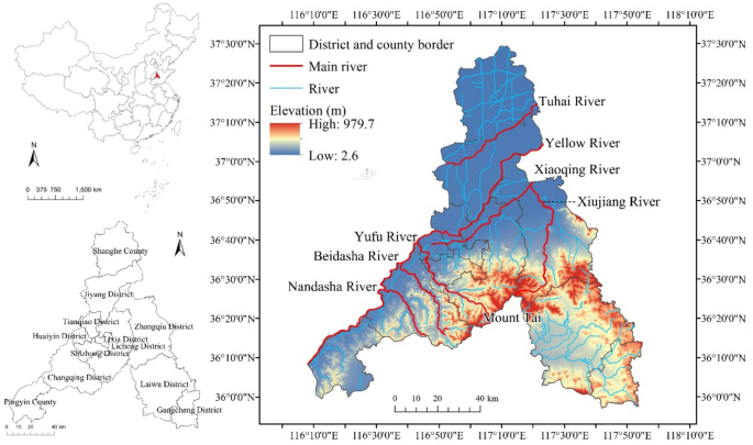
Jinan is located in the central part of Shandong Province, China, between latitudes 36°01′–37°32′ N and longitudes 116°21′–117°53′ E, covering an area of approximately 10,236.7 km2 (Fig. 1). The city has high elevation in the south and low in the north and contains alluvial plains in the central and northern parts and mountains and hills in the south. It features a typical continental monsoon climate, with an average annual temperature of 14. 9 °C and an annual precipitation of 1039.3 mm.
Location and natural environment of Jinan city. The map is based on the standard map downloaded from the National Catalog Service for Geographic Information of China and made through ArcGIS10.6, without modification of the bottom map boundaries. (https://www.webmap.cn/) below Fig. 2, production method is the same.
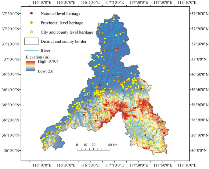
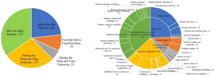
As one of the birthplaces of ancient Chinese civilization, Jinan boasts a total of 437 cultural heritage sites registered with the Cultural Relics Bureau, ranking second in Shandong Province after Jining City, which has 556 sites. In this study, a field investigation was conducted on Jinan’s cultural heritage, with a total of 448 cultural heritage sites obtained as study objects after sorting the merged information on the sites. Among these sites, there are 34 national, 178 provincial, and 236 city (county)-level cultural heritage sites (Fig. 2). Due to the large disparity in the number of cultural heritage sites preserved from each period, we referred to the relevant literature and analyzed these sites based on five periods: before the Qin Dynasty (ca. 7500 BCE–221 BCE), from the Qin to Tang Dynasties (221 BCE–CE 960), the Song and Yuan Dynasties (CE 960–1368), the Ming and Qing Dynasties (CE 1368–1912), and after the Qing Dynasty (CE 1912–present)24,25(Fig. 3). We also divided them into five categories, namely, ancient site, ancient tomb, cave and stone carvings, ancient architecture, and important historical site and architecture in modern times; 35 subcategories were identified according to the classification specified in the Law of the People’s Republic of China on the Protection of Cultural Relics (Table 1, Fig. 3).
Data sources and processing
The cultural heritage data were sourced from the official website of the Jinan Cultural and Tourism Bureau (http://www.jnwl.jinan.gov.cn/). The coordinate data were obtained from Google Earth and confirmed using the coordinate selection system in Baidu Maps. The data on the administrative division in Jinan is from the National Catalog Service for Geographic Information (https://www.webmap.cn/), and the elevation data and river data are from the Resources and Resource and Environment Science and Data Center, Chinese Academy of Sciences (https://www.resdc.cn/), and the National Earth System Science Data Center, respectively (https://www.geodata.cn/).
Research methodology
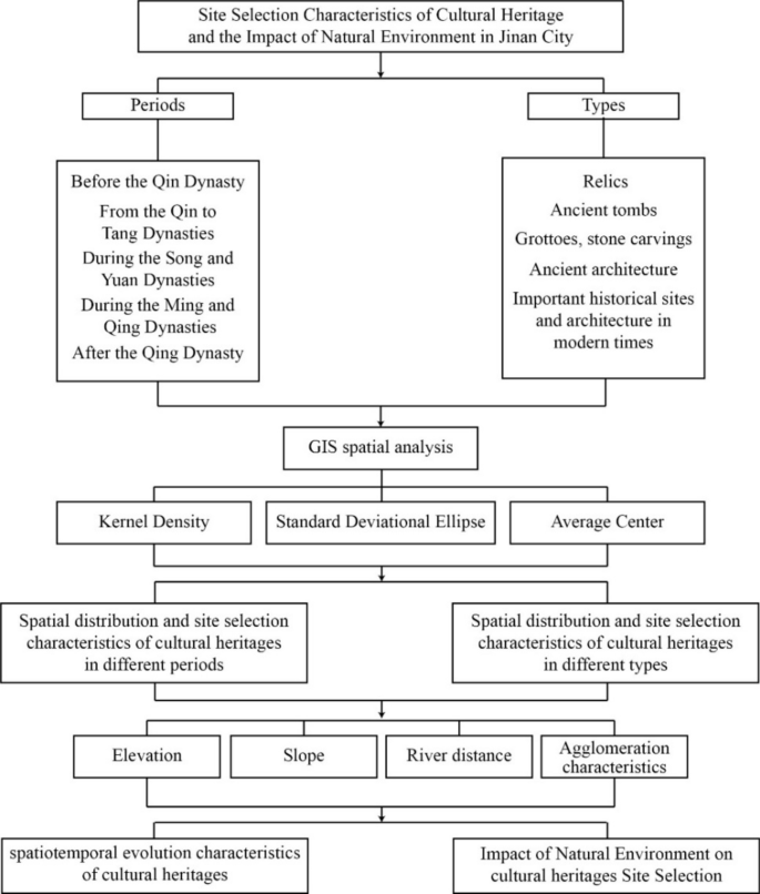
For the analysis of the spatial distribution and site selection characteristics of cultural heritage sites in Jinan, we used the following functions of ArcGIS 10.6, Kernel Density Estimation, Standard Deviational Ellipse, and Average Center Analytical. The specific analysis process is shown in Fig. 4.
Kernel density estimation method
The kernel density shows the spatial distribution characteristics of point features in the study area26,27. In this study, for the analysis of local variations in the cultural heritage sites of Jinan, the following formula was adopted to visualize the spatial distribution model of kernel density:
In the formula, the kernel density was estimated as the probability that the density function f is valid at point x, where (k(fracx-x_ih)) is the kernel function, h is the search radius, which must be greater than 0, and the distance (km) between the estimated point x and the point of interest xi is considered21.
Standard deviational ellipse analytical method
The Standard Deviational Ellipse (SDE) is a spatial statistical tool that quantifies the spatial attributes of cultural heritage sites and reveals dispersion, and directional trends28. This tool creates a new output characteristic that includes elliptical polygons. The attribute values of these elliptical polygons include an X coordinate and Y coordinate in the average center, two standard distances (the long axis and short axis) and the directions of the ellipses29. The formulas for the standard deviational ellipse are:
where x and y are the coordinates of characteristic i; (\overlineX , overlineY ) represents the center of the mean value of the characteristics; and n indicates the total of the characteristics29. The computational formulas for the rotation angle are
where (widetildex_i) and (widetildey_i) represent the deviations of the x coordinate and y coordinate from the average center, respectively. The standard deviation values of the x-axis and y-axis are
The average center analytical method
The average center refers to the average x coordinate and y coordinate of all the elements in the survey region30. The average center can directly represent the changes in the spatial distribution of cultural heritage sites during historical periods in Jinan. It can be represented as follows:
where xi and yi indicate the coordinates of element i, and n is the total number of elements.
Research results
Overall spatial distribution of cultural heritage sites in Jinan
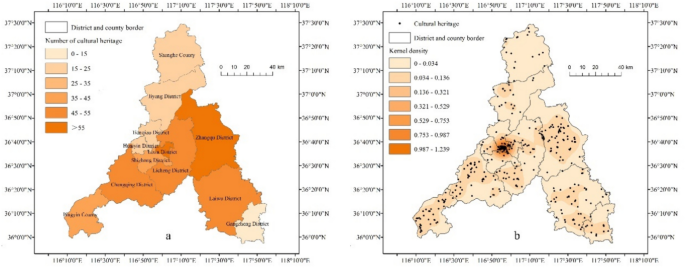
A visual analysis of the spatial distribution of cultural heritage sites in Jinan was conducted using ArcGIS 10.6. In terms of the number of cultural heritage sites, Zhangqiu District and Lixia District rank as the top two among all districts and counties (accounting for 15% and 14% of all sites, respectively), with each accounting for more than 55 sites, followed by Licheng District, Laiwu District, and Changqing District. The location with the lowest number of sites was Gangcheng District, with only 14 sites (Fig. 5a). The results of the kernel density analysis of cultural heritage sites show that the spatial distribution of cultural heritage sites in Jinan has a high-density area—the intersection of Lixia, Shizhong, Huaiyin, and Tianqiao District (Fig. 5b). Centered around this area, many cultural heritage sites are gathered in a circular pattern, showing a general characteristic of “a wide distribution with few cores”.
Spatial distribution and site selection characteristics of cultural heritage sites in different periods
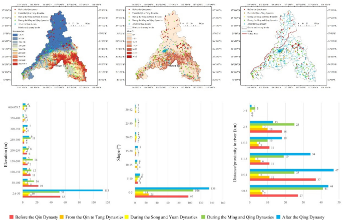
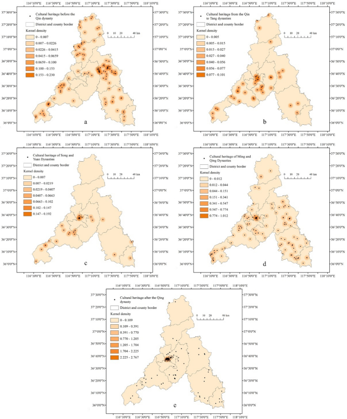
Studies on archaeological sites in China31,32 and other countries33,34 have shown that the locations of cultural heritage sites are closely related to factors such as topography, water systems, politics, and the economy. This study utilizes ArcGIS software to integrate Jinan’s spatial data of cultural heritage sites with elevation, slope, and maps of the river system, revealing the distribution of cultural heritage sites in the natural environment in each period. For better analysis, we used the equal interval method35, combined with the topographical conditions of Jinan city, to divide the elevation data, slope data, and water system maps into nine, seven, and five levels, respectively, and the results are shown in Fig. 6. Moreover, a kernel density analysis tool is adapted to visualize the site selection and clustering characteristics of cultural heritage sites in each period (Fig. 7).
Before the Qin dynasty
The analysis revealed that more than 50% of the cultural heritage sites from before the Qin Dynasty are located in areas with an elevation of 50 m, a slope of 5°, and a distance of less than 1 km from the river system. In terms of spatial distribution, they are mainly situated in the northern and central plains. This is because in ancient China where agricultural society was dominant36, the human ability to transform nature was weakened by limited economic activities and construction techniques. In this context, early humans in China tended to settle in wide plains, an ideal choice for grain cultivation, and built villages there37,38, leaving behind a great deal of heritage. Nuclear density analysis also confirmed the presence of multiple high-density cultural heritage zones in the plain area of the Zhangqiu District.
From the Qin to Tang dynasties
As before the Qin dynasty, the locations of cultural heritage sites from the Qin to Tang dynasties are characterized by low elevation and slope. However, an increase in the distance from water systems was observed, with the proportion of cultural heritage sites located within 2–5 km of river systems increasing to 25.6%. Regarding spatial distribution, cultural heritage sites began to concentrate in the south, forming a high-density area in Lixia District and Licheng District. In the year 201 B.C., the construction of Lixia County was begun on the west side of the tributary of the Xiaoqing River; thereafter, it was expanded in the North and South Dynasties and the Tang Dynasty, and by 820 A.D., a mature city form had been created. Urban construction attracted a large population and abundant resources, which helped establish a prosperous economic and cultural hub21, thus explaining why cultural heritage sites are gathered in the surrounding areas.
During the Song and Yuan dynasties
During this period, Jinan, as a military post in northern China, was in a state of war and social unrest. As a result, fewer cultural heritage sites remain, all of which are distributed in the plains in front of the mountains on the south bank of the Yellow River and in the hilly and mountainous areas in the south. Moreover, as architectural technology advanced, the number of cultural heritage sites in mountainous and hilly areas increased to 34.6%, and their distance from river systems showed less variation. This reflects the fact that changes in living and production conditions led to a gradually expanded scope of human activities and the transformation of hilly areas by humans. The kernel density analysis revealed that the core areas of cultural heritage shifted to the northwest, collecting in Lixia District, which has been assumed to be the location of Qizhou city in the Song dynasty.
During the Ming and Qing dynasties
Cultural heritage sites from the Ming and Qing Dynasties are mostly located at an elevation of 2.6–100 m and a slope of 0–5°. Compared with the previous two periods, the distance from river systems is shorter, with the proportion of heritage sites below 500 m increasing significantly to 33.3%. Despite their wide distribution in various districts and counties of Jinan, these sites are mostly concentrated on the plains and hills on the southern bank of the Yellow River, sharing the core areas with sites from the Song and Yuan dynasties. This is because the Jinan prefectural city expanded based on the city of Qizhou during the Ming and Qing dynasties, when the Lixia District became the political, economic, and cultural center of Jinan, thus laying the foundation for the “single core� distribution pattern of Jinan’s cultural heritage.
After the Qing dynasty
After the Qing dynasty, despite the gradual maturation of technology, humanity slowed the process of exploring and transforming nature. The proportion of cultural heritage sites at low altitudes and slopes increased, with more than 70% concentrated in areas with an elevation of 2.6–50 m and slopes of 0–5°. Moreover, the percentage of cultural heritage sites within 1 km of river systems increased to 58% due to increasing dependence on river systems. At the end of the nineteenth century, Qingdao and Yantai in Shandong Province were forced to open ports one after another, becoming trading hubs for ships. The resulting economic rise also had a certain impact on Jinan39. At the beginning of the twentieth century, as the Jiaozhou–Jinan Railway opened to traffic, the government decided on its own to build a commercial district on the west side of the former Jinan prefecture. Just a few decades later, Jinan became a major commercial and transportation hub of North China, second only to Beijing and Tianjin. The kernel density analysis confirmed that regions with high density slightly shifted to the west where more than 50% of the cultural heritage sites from this period are concentrated.
Spatial distributions and selection characteristics of different types of cultural heritage sites
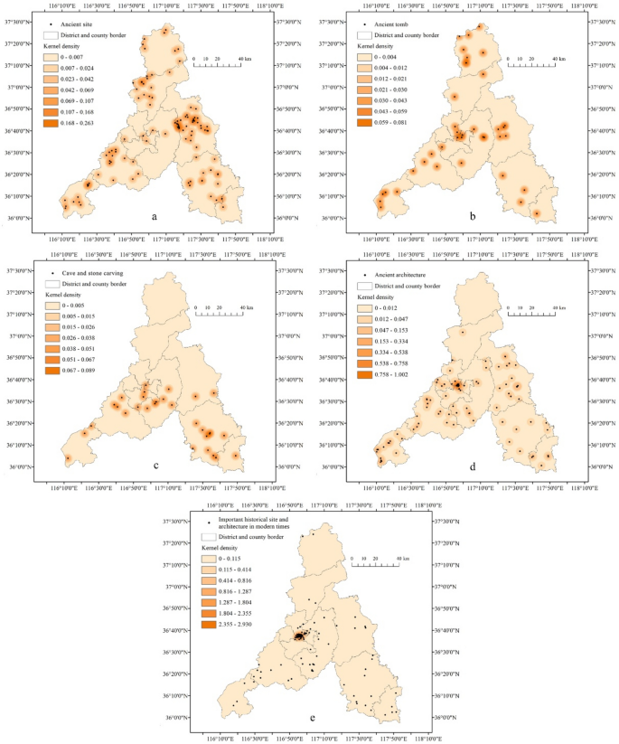
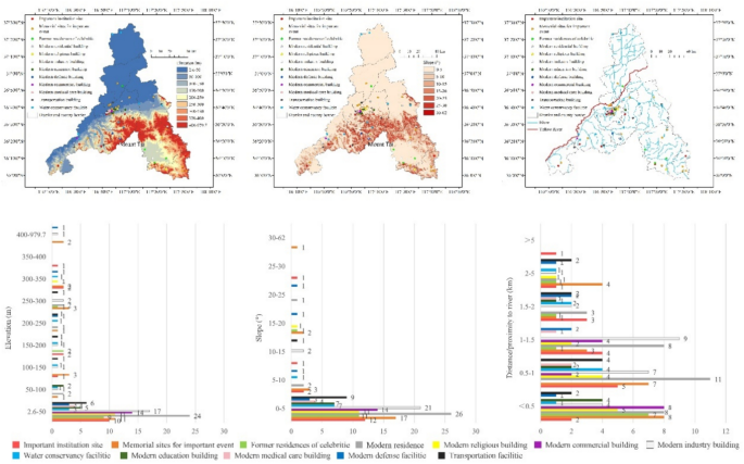
As with construction time, the selection of different types of cultural heritage sites is influenced by a variety of factors. Accordingly, this study adopted ArcGIS software to integrate spatial data on the various cultural heritage sites of Jinan with height, slope, and river system maps to further explore the selection characteristics of these sites via the Kernel Density tool (Fig. 8).
Ancient sites
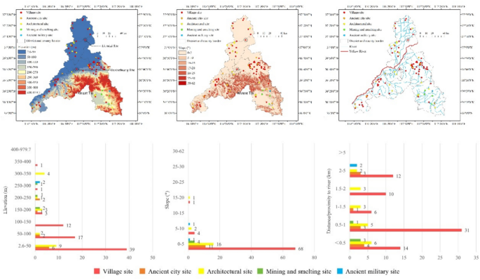
The 109 ancient sites in Jinan include five specific types: village sites, ancient city sites, architectural sites, mining and smelting sites, and ancient military sites. They are mainly distributed on alluvial plains characterized by flat terrain below 50 m in elevation, with the majority being located within 1 km of river systems (accounting for 61.5%) (Fig. 9). Therefore, it can be seen that topography and water sources were important factors influencing site selection in Jinan during ancient times. The locations of national-level heritage sites, such as the Daxinzhuang and Liutaizi sites can indirectly confirm this. After exploring the spatial distributions of specific types of sites, we found that villages, old cities, and architectural sites are mostly distributed in relatively flat areas, while mining and smelting sites and ancient military sites are concentrated on hills with heights greater than 200 m in Laiwu District. The kernel density analysis revealed that several core areas of ancient sites appear in the Zhangqiu District, similar to the pre-Qin period. This low variability in the spatial distribution is due to the fact that most of the sites in Jinan are remains of human activities in primitive societies.
Ancient tombs
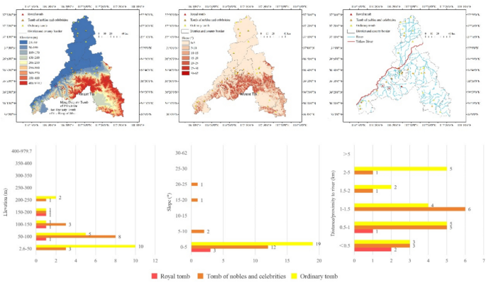
Jinan has a total of 38 ancient tombs, consisting of three specific types: royal tombs, tombs of nobles and celebrities, and ordinary tombs. Judging from the location characteristics, these tombs are situated at low elevations and on low slopes, with fewer variations in the distance from river systems (Fig. 10). Royal tombs and tombs of nobles and celebrities are mainly distributed around Mount Tai in the south (such as the Han dynasty tomb of the king of Jibei and the Ming dynasty tomb of prince De), consistent with the pattern that “tombs are built against mountains” noted in the Book of Burial. In contrast, most common tombs are family tombs and are primarily located near villages and cities in the central or northern plains. Overall, the distribution of ancient tombs is relatively scattered, without obvious spatial characteristics. Similarly, the results of the kernel density analysis show that compared with other types of cultural heritage, ancient tombs form more core areas with wider distributions.
Caves and stone carvings
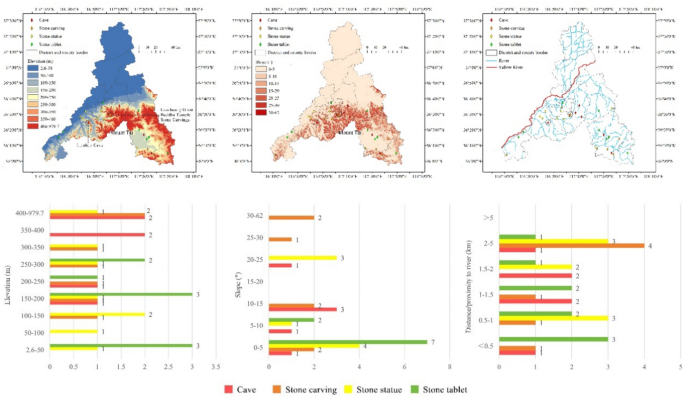
The category of caves and stone carvings includes religious temples, statues, inscriptions, and other features that are carved into cliffs or stones40. In Jinan these features are classified into four specific types: caves, stone carvings, stone tablets, and stone statues (Fig. 11). Caves, stone carvings, and stone statues are mostly examples of religious cultural heritage, such as the Lianhua cave and the Laozhuang Great Buddha Temple stone carvings. These are mainly distributed in the southern mountains or foothills on gentle slopes, with an elevation of 150 m and a distance of more than 1 km from river systems. In comparison, the inscriptions are mainly concentrated in the northwestern and central areas of Mount Tai, which has an elevation of 200 m and a slope of < 10°, where the terrain is low and gentle. Overall, caves and stone carvings occur in a number of core areas in Laiwu District and southern Licheng District. The strong religious nature of this type of cultural heritage also reflects the high status of Mount Tai in traditional Chinese beliefs.
Ancient architecture
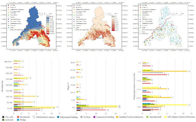
The ancient architecture of Jinan consists of 13 specific types: city walls, residential buildings, Buddhist/Taoist architecture, folk religion-related architecture, ancestral halls, pavilions, educational buildings, commercial buildings, courtyards, administrative agencies, and bridges, which vary in site selection characteristics (Fig. 12). City walls, dwellings, pavilions, ancestral halls, educational buildings, government offices, commercial buildings, and courtyards, as important parts of settlements and cities, are mainly distributed on the central plains with an elevation of 200 m, a slope of 5° and a distance of less than 1 km from river systems. This distribution is considered a result of the dense river network in the central plain area and the natural ecological barrier in the southern mountainous area, and it is characteristic of an ideal settlement and development area influenced by the ancient Chinese art of Feng Shui. Buddhist/Taoist and folk religion-related buildings have similar spatial distributions and site selection characteristics and are distributed in plains and mountainous areas with gentle slopes on the southern bank of the Yellow River. The difference is that the locations of folk religion-related buildings vary depending on the gods worshipped. The City God Temple, for instance, is dedicated to the guardian god of ancient cities. These buildings developed with the founding of cities and mainly appeared in urban areas. Dragon King temples, on the other hand, are sites of worship for the Dragon God, where people pray for a good harvest, and are mainly located along rivers. Only two bridges in Jinan show obvious functional characteristics in site selection; these are distributed above the tributaries on the southern banks of the Yellow River and the Yufu River. The kernel density analysis indicated that ancient buildings form a core area in Lixia District. As mentioned above, with the construction and development of the city after the Song dynasty, this district gradually became Jinan’s core area, where a large number of resources and facilities were gathered.
Important historical sites and architecture in modern times
Important historical sites and architecture in modern times can be subdivided into 12 categories: important institutional sites, memorial sites for important events, former residences of celebrities, modern residences, modern religious buildings, modern commercial buildings, modern industrial buildings, modern educational buildings, modern medical care buildings, modern defense facilities, transportation facilities, and water conservancy facilities. They are concentrated in plain areas with an elevation of 50 m, a slope of 5°, and a distance of < 1 km from river systems, and they have lower elevations and slopes and shorter distances from river systems than the other types of cultural heritage (Fig. 13). In terms of spatial distribution, they mainly appear in Lixia District. This is because Lixia District is the development center of Jinan in modern times, and Jinan Station, an important railway hub in Shandong, is also situated there. Therefore, emerging industries such as modern commerce, industry, and health care have become aggregated in this district. Additionally, it is the location of government agencies and consulates of various countries, attracting numerous foreign immigrants to settle there and thus leading to a high density of cultural heritage. This is confirmed by the results of the kernel density analysis, which shows that this type of cultural heritage, compared to ancient buildings, is more obviously clustered in Lixia District, with small dispersion.
Discussion
The spatiotemporal evolution of cultural heritage sites in Jinan city
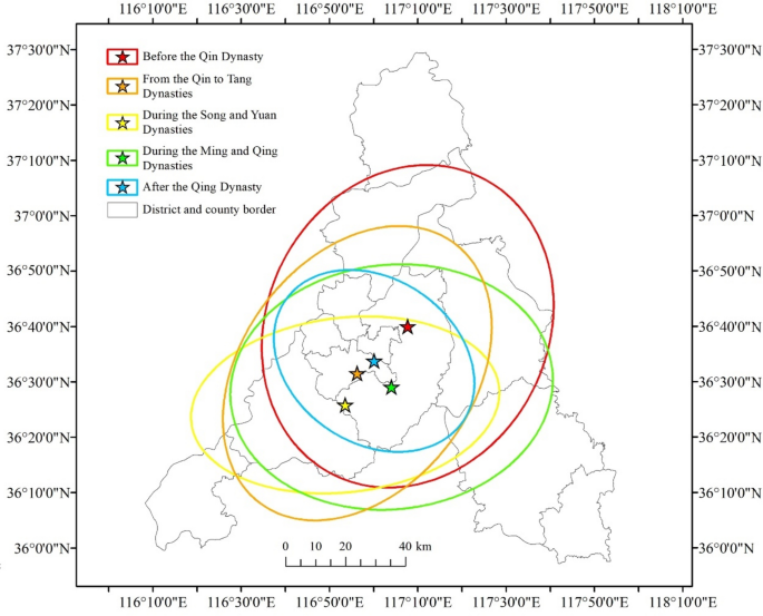
The spatial analysis tools in GIS capture the directionality of the spatial distribution and the center of gravity of Jinan’s cultural heritage sites during various time periods, thus facilitating the analysis of their spatiotemporal evolution. The results obtained from the SDE tool in ArcGIS 10.6 show that cultural heritage sites from before the Qin Dynasty are scattered, and the SDE axis is large (Fig. 11). This dispersion continued for sites from the Song and Yuan Dynasties; the short axis of the SDE is slightly reduced, the cultural heritage sites are clustered, and the direction of the axis is deflected to 86°. For the Ming and Qing Dynasties, the short axis of the SDE increases significantly, indicating an expansion in the distribution of cultural heritage sites during this period. After the Qing Dynasty, the length of the SDE axis drastically decreased, and the cultural heritage sites showed a dense distribution characterized by a shift in direction from 87° to 127°. Overall, the spatial and temporal evolution of Jinan’s cultural heritage sites follows a “diffusion-aggregation-diffusion-aggregation� trend, and the direction of the SDE rotates counterclockwise by nearly 100°. Despite a significant process of evolution, continuity in direction is revealed.
Regarding the average center trajectory (Fig. 14), the distribution center of cultural heritage sites generally shows a “southwest-northeast-northwest� trend, which is similar to the direction of deflection of the long axis of the SDE. Although the average center point does not overlap with the core area of cultural heritage in terms of spatial location, the trajectory after the Qin dynasty features a circular pattern around a point and is characterized by concentricity. This also indirectly proves that the historical traces of the development of Jinan after the Qin Dynasty spread outward around this same space.
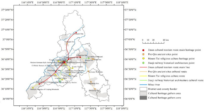
Therefore, we recommend that Jinan adopt the concept of regional-scale linear heritage, as proposed in the United States and Europe41,42. Centered around Lixia District, which has more cultural heritage sites and is located in a core cluster area, the city can create cultural tourism routes connecting various districts and counties. By fostering inter-regional connections, this approach would establish a more systematic framework for heritage protection and development, helping the cultural heritage of Jinan transition from mere conservation to the facilitation of a wider array of social functions. Considering the construction periods and concentration areas, we propose three thematic routes, these include the ‘Pre-Qin ancient sites cultural route’, the ‘Mount Tai religious culture route’, and the ‘Jiaoji railway historical architecture cultural route’. These themed routes offer fresh perspectives for regional heritage protection initiatives in Jinan (Fig. 15).
Impact of the natural environment on cultural heritage site selection
Judging from the spatial distribution and site selection characteristics, most cultural heritage sites during various time periods in Jinan are concentrated in alluvial plain areas (elevation: 2.6–100 m; slope: 0–5°; distance from river systems: < 1 km). To capture the influence of the natural environment on site selection characteristics, this study uses the median value as a criterion for comparison. The comparison results for each period (Fig. 16) show that the elevation and slope of cultural heritage sites after the Qing dynasty are relatively low, with the locations being closer to river systems. The median elevation, slope, and distance from river systems are 41 m, 0.9°, and 773 m, respectively. In contrast, the Qin to Tang Dynasties feature the highest elevation and slope and the greatest distance from river systems; the median values of these three indicators are 135 m, 3.7°, and 1229 m, respectively. A horizontal comparison of site selection characteristics across the five periods shows that the dependence on terrain and water systems has a trend of first increasing and then decreasing. The closer to modern times the year of construction is, the stronger the dependence on the natural environment.
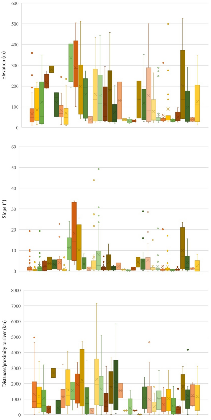
By comparing the median values of the influencing factors on site selection of different types of cultural heritage (Fig. 17), it is seen that the elevation and slope are relatively low. The types of cultural heritage sites adjacent to river systems are city walls, commercial buildings, courtyards, government offices, former residences of famous people, and sites related to modern commerce and education, which are distributed in areas with an elevation of 30–45 m, slope of 0–1.2°, and distance from river systems of 60–350 m. Among all types of sites, courtyards have the lowest elevation and slope and the shortest distance from water systems, with the median values of elevation, slopes, and distances to water systems being 30.7 m, 0.4°, and 61.3 m, respectively. In contrast, the types with a high elevation and slope and great distance to water systems include ancient military sites, caves, stone carvings, stone statues, and modern defense buildings, with an elevation of 195–395 m, a slope of 3.5–14.5°, and a distance to river systems of 1.7–2.7 km. Among these, ancient military sites are the farthest from water systems, with a median distance of 2.7 km, while caves have the highest median height among all the types, at 394.3 m. These types of cultural heritage sites share the following characteristics: (1) they are located in mountainous and hilly areas, and (2) they are less connected to everyday life.
Box diagram of cultural heritage sites of different types in Jinan city at different elevations, slopes, anddistances/proximity to rivers. (From left to right: village sites, ancient city sites, architectural sites, mining and smelting sites, ancient military sites, royal tombs, tombs of nobles and celebrities, ordinary tombs, caves, stone carvings, stone statues, stone tablets, city walls, residential buildings, Buddhist/Taoist architecture, folk religion-related architecture, ancestral halls, pavilions, educational buildings, commercial buildings, courtyards, administrative agencies, bridges, important institutional sites, memorial sites for important events, former residences of celebrities, modern residences, modern religious buildings, modern commercial buildings, modern industrial buildings, modern educational buildings, modern medical care buildings, modern defense facilities, transportation facilities, and water conservancy facilities).
Regarding the selection of cultural heritage sites of different periods and types, the ability of human beings to transform the natural environment increases with increasing productivity. Despite increased human adaptability to varying environments, terrain and water systems play a decisive role in production and life in Jinan. Thus, plains with abundant rivers are an important factor in the aggregation of cities, villages, and cultural heritage sites. This finding is largely consistent with the conclusions drawn by Li, W., et al.28, who studied the spatial and temporal differentiation characteristics of cultural heritage in the Yellow River Basin. However, some previous researchers have analyzed only the factors that influence spatial distribution for cultural heritage during specific periods or focused on single types of heritage28,43,44, lacking sufficient descriptions of the spatial characteristics of different types of cultural heritage. For example, in Zhangqiu district, ancient sites before the Qin dynasty were densely distributed, while other types of heritage are relatively sparse. It could encourage the development of local cultural industries, such as on-site archaeological experiences and traditional craftsmanship. Additionally, integration technologies like augmented reality (AR) and virtual reality (VR) to reconstruct ancient sites, rituals, and daily life can further enhance the unique experiences of visitors.
In summary, when studying the spatial distribution and influencing factors of cultural heritage in a specific area, it is essential to conduct detailed analyses at different geographic scales and for different periods, and types of heritage to make the study more comprehensive and reasonable. By comparing the distribution of cultural heritage resources in different periods and types, evidence-based proposals can be proposed to promote the sustainable development of cultural heritage in light of the actual situation of unbalanced regional development.
Conclusions
This study collected data on cultural heritage at or above the municipal level published by Jinan city and used the ArcGIS method to study the spatial distribution and selection characteristics of cultural heritage sites and how they are impacted by the natural environment. The main conclusions are as follows:
-
(1)
Cultural heritage sites have a wide distribution and few cores. Their spatial distribution is characterized by aggregation, forming a single core area around Lixia District, which has been a location of major cities since the Qin Dynasty. This indicates that there is stability and continuity in the spatial distribution pattern of cultural heritage sites and that Lixia District plays a dominant role in the historical development of Jinan.
-
(2)
The spatiotemporal evolution of cultural heritage sites follows a “diffusion-aggregation-diffusion-aggregation� trend. Although these sites cover a wide area, the center is within the boundaries of Lixia District, Licheng District, and Shizhong District. Moreover, the overall evolutionary trend shows a southwest-northeast-northwest trajectory, with a roughly similar core in each period. From the Qin period onward, it moves counterclockwise around one point, with a clear direction, strong continuity, and a centripetal pattern.
-
(3)
Most cultural heritage sites of different periods and types are distributed in alluvial plains at elevations of 2.6–100 m, with slopes ranging from 0–5° and distances from the river system of < 1 km. The more closely related to modern times the construction year is, the closer the cultural heritage type is to production and living, and the more relevant it is to the natural environment. Therefore, although the locations of Jinan’s cultural heritage sites are affected by a variety of factors, such as social development and economic and political factors, the natural environment plays a decisive role and is an important factor in making Lixia District the core area of cultural heritage and even the political and economic center of Jinan.
In conclusion, cultural heritage sites are a valuable legacy of human history, recording the delicate balance between human activities and the natural environment. Jinan, highlighting its historical landscape and cultural heritage, is submitting nomination proposals for its properties to be included in UNESCO’s World Heritage List. Therefore, this study may assist Jinan’s cultural heritage department in identifying areas deserving of more attention in the future and provide a reference for subsequent studies on the protection and risk assessment of cultural heritage.
Data availability
All research data obtained during this study are included in this article. The raw data are available from the corresponding author on reasonable request.
References
-
Zhang, J., Jiang, L., Wang, X., Chen, Z. & Xu, S. A study on the spatiotemporal aggregation and corridor distribution characteristics of cultural heritage: the case of Fuzhou, China. Build. Basel. 14(1), 12 (2024).
-
Vecco, M. A definition of cultural heritage: from the tangible to the intangible. J. Cult. Hearit. 11(3), 321–324 (2010).
-
Ngo, L.-M. & Anh, T. D. A new development model for traditional craft villages in urban fringes: a case study in Ho Chi Minh City. Vietnam. J. Region City Plan. 32(2), 99–109 (2021).
-
Bathrellos, G. D., Gaki-Papanastassiou, K., Skilodimou, H. D., Papanastassiou, D. & Chousianitis, K. G. Potential suitability for urban planning and industry development using natural hazard maps and geological–geomorphological parameters. Environ. Earth Sci. 66, 537–548 (2012).
-
Bathrellos, G. D. & Skilodimou, H. D. Estimation of sand and gravel extraction sites. Z. Geomorphol. 63, 313–328 (2022).
-
Santos, B., Gonçalves, J., Almeida, P. G. & Martins-Nepomuceno, A. M. T. GIS-based inventory for safeguarding and promoting Portuguese glazed tiles cultural heritage. Herit. Sci. 11(1), 133 (2023).
-
Prus, B., Dudzińska, M. & Bacior, S. Determining and quantifying the historical traces of spatial land arrangements in rural landscapes of central and Eastern Europe. Sci. Rep. 11(1), 23421 (2021).
-
Bozdağ, A. A spatial analysis for sustainable planning of tourism impacts using GIS: cesme (cyssus), İzmir. Turkey. Environ. Dev. Sustain. 25(9), 9877–9902 (2023).
-
Cai, Z., Fang, C., Zhang, Q. & Chen, F. Joint development of cultural heritage protection and tourism: the case of Mount Lushan cultural landscape heritage site. Herit. Sci. 9(1), 86 (2021).
-
Altaba, P., GarcÃa-Esparza, J. A. & ValentÃn, A. Assembling cultural and natural values in vernacular landscapes: an experimental analysis. Remote Sens.-Basel. 14(17), 4155 (2022).
-
Sang, K., Fontana, G. L. & Piovan, S. E. Assessing railway landscape by AHP process with GIS: a study of the Yunnan-Vietnam railway. Remote Sens.-Basel. 14(3), 603 (2022).
-
Nuno Martins, A., Pereira, A. A., Forbes, C., de João Lima, L. M. P. & Matos, D. Risk to cultural heritage in Baixa Pombal Ina (Lisbon downtown)-a transdisciplinary approach to exposure and drivers of vulnerability. Int. J. Archit. Herit. 15(7), 1058–1080 (2021).
-
Yagoub, M. M. & Yammahi, A. A. A. Spatial distribution of natural hazards and their proximity to heritage sites: case of the united arab emirates. Int. J. Disast. Risk Red. 71, 102827 (2022).
-
Lombardo, Luigi, Hakan Tanyas, Ionut Cristi Nicu. 2020 Spatial modeling of multi-hazard threat to cultural heritage sites. Eng. Geol. 277, 105776
-
Mihu-Pintilie Alin. & Ionut Cristi Nicu. GIS-based landform classification of eneolithic archaeological sites in the plateau-plain transition zone (NE Romania): Habitation practices vs. flood hazard perception. Remote Sens.-Basel. 11, 915 (2019).
-
The case study of Paphos area. Agapiou, Athos. et al. Cultural heritage management and monitoring using remote sensing data and GIS. Cyprus. Compu.t Environ. Urban. 54, 230–239 (2015).
-
Nicu, Ionut Cristi. Cultural heritage assessment and vulnerability using Analytic Hierarchy Process and Geographic Information Systems (Valea Oii catchment, North-eastern Romania). An approach to historical maps. Int. J. Disast. Risk Red. 20, 103–111 (2016).
-
Zhang J, Wang X, Jiang L, Chen Z, Xu S. & Aoki N. Analysis of the evolution pattern and regional conservation of cultural heritage from the perspective of urban sustainable transformation: the case of Xiamen, China. Build.-Basel 14(3), 565 (2024).
-
Li C, Qian Y, Li Z. & Tong T. Identifying factors influencing the spatial distribution of minority cultural heritage in Southwest China. Herit. Sci 12(1), 117 (2024).
-
Gao H, Wang Y, Zhang H, Huang J, Yue X. & Chen F. Spatial distribution and typological classification of heritage buildings in Southern China. Build.-Basel. 13(8), 2025 (2023).
-
Li, X. Determination of the temporal–spatial distribution patterns of ancient heritage sites in China and their influencing factors via GIS. Herit. Sci. 12(1), 143 (2024).
-
Jiang, L. & Cai, J. Research on the spatial and temporal distribution and evolution characteristics of ancient architectural heritage in Southeastern Zhejiang. Sustain.-Basel. 15(24), 16618 (2023).
-
Xu, Z. et al. The influence of environment on the distribution characteristics of historical buildings in the Songshan Region. Land. 11(11), 2094 (2022).
-
Jia, M. et al. Exploring the impact of climate change on flood risk at cultural heritage sites using a GIS-based SCS-CN method: A case study of Shanxi province, China.Int. J. Disast. Risk Red. 96, 103968 (2023).
-
Liu Y, Chen M. Tian Y. Temporal and spatial patterns and influencing factors of intangible cultural heritage: ancient Qin-Shu roads, Western China. Herit. Sci. 10(1), 201 (2022).
-
Wei G, Lang X. & Han G. Research on the protection of and renewal strategies for historic buildings in the ancient city of Liaocheng based on multisource data. Archit. Eng. Des. Manag. https://doi.org/10.1080/17452007.2024.2355892 (2024).
-
Zhang, Z., Cui, Z., Fan, T., Ruan, S. & Wu, J. Spatial distribution of intangible cultural heritage resources in China and its influencing factors. Sci. Rep. 14(1), 4960 (2024).
-
Li W, Jiao J, Qi J. & Ma Y. The spatial and temporal differentiation characteristics of cultural heritage in the Yellow River Basin. PLoS one 17(6), e0268921 (2022).
-
Zhao Y, Bian G, Sun T. & Yan J. The in-situ spatial-temporal evolution of the settlement space along the grand canal Tianjin section from the perspective of cultural heritage. Land 12(5), 1023 (2023).
-
Mitchell, A. & Griffin, L. S. The esri guide to GIS analysis, spatial measurements and statistics 2nd Edition. ESRI Press. (2021).
-
Guo Y, Mo D, Mao L, Wang S. & Li S. Settlement distribution and its relationship with environmental changes from the Neolithic to Shang-Zhou dynasties in northern Shandong, China. J. Geogr. Sci. 23, 679–694 (2013).
-
Zheng C, Zhu C, Zhong Y, Yin P, Bai J. & Sun Z. Relationship between the temporal–spatial distribution of archaeological sites and natural environment from the paleolithic age to the tang and song dynasties in the three gorges reservoir of Chongqing area. Chin. Sci. Bull. 53,107–128 (2008).
-
Noviello, M., Cafarelli, B., Calculli, C., Sarris, A. & Mairota, P. Investigating the distribution of archaeological sites: Multiparametric vs probability models and potentials for remote sensing data. Appl. Geogr. 95, 34–44 (2018).
-
Nicu, I. C., Usmanov, B., Gainullin, I. & Galimova, M. Shoreline dynamics and evaluation of cultural heritage sites on the shores of large reservoirs: Kuibyshev Reservoir, Russian Federation. Water-Sui 11(3), 591 (2019).
-
Fu, J. & Mao, H. Study on the spatiotemporal distribution patterns and influencing factors of cultural heritage: a case study of Fujian Province. Herit. Sci. 12(1), 324 (2024).
-
Shen J, Huang F-T. & Chou R-J. Agricultural-heritage-oriented rural revitalization: experiences from the ancient tea town of Xiping. Land. 10(9):927 (2021).
-
Tan, B. et al. The study of early human settlement preference and settlement prediction in Xinjiang, China. Sci. Rep. 12(1), 5072 (2022).
-
Wu, L. et al. Evolution of Neolithic site distribution (9.0–4.0 ka BP) in Anhui, East China. J. Geogr. Sci. 30, 1451–1466 (2020).
-
So, Fion Wai Ling. Germany’s colony in China: colonialism, protection and economic development in Qingdao and Shandong, 1898–1914. Routledge. (2019).
-
Zhang Y, Zhang Y. & Huang J. Experimental study on capillary water absorption of sandstones from different grotto heritage sites in China. Herit. Sci. 10(1), 25 (2022).
-
Bogacz-Wojtanowska, E., Góral, A. & Bugdol, M. The role of trust in sustainable heritage management networks. case study of selected cultural routes in Poland. Sustain. Basel. 11(10), 2844 (2019).
-
Božić, S. & Tomić, N. Developing the cultural route evaluation model (CREM) and its application on the Trail of Roman Emperors, Serbia.Tour. Manag. Perspect. 17, 26–35 (2016).
-
Wang, H. et al. Research on the Spatiotemporal Distribution and Cultural Tourism Strategy of Modern Educational Architectural Heritage in Nanjing. Sustain.-Basel. 15(19), 14392 (2023).
-
Fan, X. & Sun, L. Geographic Distribution Characteristics and Influencing Factors for Industrial Heritage Sites in Italy Based on GIS. Sustain.-Basel. 16(5), 2085 (2024).
Author information
Authors and Affiliations
Contributions
GW analyzed the data and drafted and revised the manuscript. GW and G-SH conducted the tests and analyzed the data. G-SH and XL reviewed the manuscript and provided support and guidance for this work. All authors reviewed the manuscript.
Corresponding author
Correspondence to
Guanyu Wei.
Ethics declarations
Competing interests
The authors declare no competing interests.
Additional information
Publisher’s note
Springer Nature remains neutral with regard to jurisdictional claims in published maps and institutional affiliations.
Supplementary Information
Rights and permissions
Open Access This article is licensed under a Creative Commons Attribution-NonCommercial-NoDerivatives 4.0 International License, which permits any non-commercial use, sharing, distribution and reproduction in any medium or format, as long as you give appropriate credit to the original author(s) and the source, provide a link to the Creative Commons licence, and indicate if you modified the licensed material. You do not have permission under this licence to share adapted material derived from this article or parts of it. The images or other third party material in this article are included in the article’s Creative Commons licence, unless indicated otherwise in a credit line to the material. If material is not included in the article’s Creative Commons licence and your intended use is not permitted by statutory regulation or exceeds the permitted use, you will need to obtain permission directly from the copyright holder. To view a copy of this licence, visit http://creativecommons.org/licenses/by-nc-nd/4.0/.
About this article
Cite this article
Wei, G., Han, GS. & Lang, X. Cultural heritage site selection characteristics and the impact of the natural environment in Jinan city, China.
Sci Rep 14, 31038 (2024). https://doi.org/10.1038/s41598-024-82201-4
-
Received: 21 August 2024
-
Accepted: 03 December 2024
-
Published: 28 December 2024
-
DOI: https://doi.org/10.1038/s41598-024-82201-4
Keywords
Search
RECENT PRESS RELEASES
Related Post
