Data management and the orbital environment: Finding the needle in the haystack
June 11, 2025
With a rapid increase in the number of objects in orbit, there is a requirement to increase available data to support safe, sustainable, and secure space operations.
It is something of a cliche to say that the orbital environment has undergone a dramatic change both in usage and occupation over the course of the last decade, and more particularly over the last five years with the proliferation of both reusable launch vehicles and mega constellations. The ten-fold increase in human-made space objects has been matched by a consequential growth in the amount of data regarding the space environment.
Even though there has been an exponential growth of commercial space situational awareness (SSA) companies, much remains the same regarding the availability of data on operations in near-Earth space. In its simplest form, space situational awareness is the understanding of what is going into, coming out of, and happening in space, but the availability of data to support it is far from simple.
Meeting an increased need for space data
A space traffic study conducted in 2021 projected that data volumes from and about space will reach more than 500 exabytes of information over the course of the current decade. This represents a staggering 14-fold increase over ten years.¹ To promote an increase in the amount of space data, at 3S Northumbria, we have been evangelical in our calls for increased space surveillance and tracking capability. This is needed to meet the requirements of both current and future space traffic management/space traffic coordination in enabling a safe, sustainable and secure future for near-Earth space operations – out to 36,000km (the geostationary ‘belt’).
With a data volume equivalent to 3.9 billion smartphones of data over the next ten years, acquiring information is only the first part of understanding, analysing and hopefully coordinating the orbital environment. This discussion will highlight some of the issues in space data management in all its forms and suggest some of the crucial steps needed to deal with the dramatic increase in space objects and ensure safe operations in space.

Understanding low-Earth orbit
Any discussion on data from and about space needs to start by acknowledging the emergence of large constellations and the dramatic increase in the number of space objects in low-Earth orbit (LEO). At the time of writing, there are over 13,000 active satellites in orbit, with more than 60% of them belonging to one owner/operator, the Starlink constellation. These large-scale deployments of smaller satellites create a significant increase in data generation rates. To provide a full picture for space situational awareness, each satellite requires continuous tracking, collision avoidance assessment, and subsequent coordination with objects and phenomena in the wider orbital environment.
The Starlink constellation publishes bi-annual manoeuvre reports² and employs an autonomous collision avoidance algorithm that ensures each satellite can manoeuvre to maintain safety from other satellites in its path. However, each manoeuvre reduces the orbital life span of the satellite, which carries a finite ‘fuel’ supply, and the accuracy of conjunction prediction is questionable at best.
The implications of the sheer amount of data required/generated move us beyond simple object tracking. There is data generated in respect of orbital propagation calculations, manoeuvre planning coordination, and real-time collision probability assessments. Despite the Starlink constellation benefiting from autonomous collision avoidance, other satellite users still need to consider planned orbital manoeuvres, station-keeping activities and end-of-life disposal procedures. This type of sophisticated data management needs systems that can deal with a high number of updates, manage multi-dimensional orbital data, and model complex, inter-constellation satellite relationships. This is just considering the data generated by active, operational satellites. Adding in lethal, non-trackable pieces of space debris, we then quickly run into differing requirements of object categorisation, the need for alternate detection methodologies, storage protocols and processing capabilities.
Currently, the management and sharing of data and safety of flight warnings is carried out by the US Space Force, 18th Space Defense Squadron (18SDS). This is achieved through the daily updating of SpaceTrack.org³ – a service that long predates the increase in space traffic – and providing a direct warning to operators if a conjunction is detected within a specific range of probability. Although there has been a proliferation of commercial SSA companies in the last ten years, the US Space Force still primarily relies upon the US Space Surveillance Network (SSN) as its source of data and information.
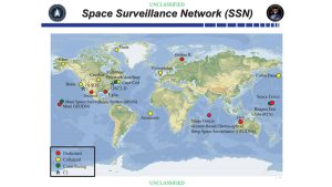
Space Surveillance Network
The SSN is a network of radar, electro-optical and passive radio frequency (RF) sensors used for missile warning, space object cataloguing and identification alongside safety and compliance monitoring. Only a few are dedicated to space tracking, with many of the ground-based radars optimised to support missile warning and defence.
The work that we undertake at 3S Northumbria, and with our American partners at Exo-Analytic Solutions, illustrates that analysing space traffic data is not just a question of managing the volume of information. It encompasses diversity and complexity in data types. To have complete space situational awareness, systems must process observational data from ground-based radar systems, optical telescopes and space-based sensors. Each one of these will generate data in different formats, have differing accuracy levels, update at different times and ultimately come from different sources.
Additionally, there are differing requirements for the different orbital regimes. Objects in LEO often require faster response times than those in geostationary orbits due to the operational dynamics of the regime. They are travelling at speeds akin to 7 km per second, orbiting the Earth in as little as 90 minutes. Therefore, warnings of any changes or dangers are short and need to be processed and executed rapidly. We haven’t even touched on the effects of the environment outside Earth’s atmosphere, which can have a significant effect on the propagation of orbits.
Utilising new technologies
Adding artificial intelligence (AI) and machine learning algorithms into the mix brings another layer of complexity. Such systems require extensive training datasets, as well as access to active sensor feeds. Often, the wealth of data needed to support effective AI is not available due to government and military classification restrictions. This is all combined with historical trend data to try to accurately predict orbital trajectories, as well as collision probabilities. As a result of all of this, any data infrastructure must accommodate not only the raw observational data but also the processed outputs from these various algorithms. Whilst these difficulties are not insurmountable, they do point to some of the difficulties encountered by policymakers and regulators when trying to manage satellite operations in Earth orbit.
Safe space operations depend upon near-real-time sharing and dissemination of information to provide collision warnings and recommend collision avoidance manoeuvres. Although the current support to operators appears adequate, it begs the question of whether it can handle any further increases in space traffic. Any hope for space traffic management in the future will rest upon the ability of data providers to furnish near-real-time data processing capabilities. Standardising information and ensuring information sharing across international borders presents not only technical challenges with respect to the format of the data. There are also procedural and institutional obstacles, with no obvious formalised lines of communication between trackers, regulators, operators, and holders of data.
Establishing procedures and policies
In addition to these procedures and processes, which need locating within the proper institutions (and these may vary depending upon the jurisdiction), there is the challenge of establishing and maintaining the quality of the data produced whilst ensuring safe, sustainable, and secure space. Currently, the contours for liability for damage caused by one space object to another are uncertain, untested and cumbersome. The Liability Convention of 1972, Article III provides that a State will be liable for damage caused by their space object if it can be shown that the space object of that State (or the persons for whom they are responsible) caused that damage. The 1972 Convention goes on to set out a quasi-diplomatic mechanism by which damages for liability can be recovered.
If, as would appear likely, the liability for damage caused on-orbit rests with the party at fault, then an operator, deciding on whether to execute a collision avoidance manoeuvre, needs to be assured that the data they are relying on is of the best possible quality. There are numerous opportunities for imaginative legal advisors to challenge the integrity of data that has been integrated from ground-based sensors and then processed by algorithms. The mechanisms for managing and sharing the data need to be as certain as those for processing and analysing that data. Operators relying on data for safe operations will be quick to question the probity of data should a collision result in expensive claims for damages for damage caused while acting upon that data.
The reliance upon this vast amount of data clearly presents several difficulties. Primary amongst these is the requirement that the data is processed, stored, and shared in a format that is widely understood. Work has been ongoing with both the Consultative Committee for Space Data Systems (CCSDS) conjunction data message standard and the emerging ISO/TC20/SC14 standard for space traffic coordination, addressing the need for recognised international standards in data collection, storage and exchange with interoperable messaging formats. Establishing standardised international data sharing protocol can be achieved but requires dialogue between all uses of space, including satellite operators, national regulators, and commercial providers of SSA information, and also requires a change in how this is provided. There is a clear argument that the safety and sustainability of space should become a civil ‘agenda’, releasing the military organisations that currently provide the support to focus on security.
Further support needed for space operators
Looking to the future, the work being undertaken by the U.S. Department of Commerce should help alleviate the problem and provide greater safety support to operators. The Office of Space Commerce in the National Oceanic and Atmospheric Administration (NOAA) is developing the Traffic Coordination System for Space (TraCSS) to provide basic SSA data and services to civil and commercial operators in support of spaceflight safety. This will mean that the future of coordinating the orbital environment will involve integrating data from an ever-increasing array of sensor technologies. It is important, however, that the industry does not lose sight of the need for increasing this capacity alongside other more glamorous ways of spending money. Increasing the data sources will inevitably lead to the provision of better, more reliable data about the orbital environment. The resulting data management infrastructure will need to be flexible enough to accommodate these new types of sensors whilst being compatible with the existing legacy systems. And it will need to be international.
This discussion has sought to highlight some of the issues regarding data management as the number of objects in orbit continues to grow at a dramatic rate. These issues do not exist in isolation – the technical, operational, and governance obstacles must be addressed together. Increasing the number and variety of sensors gathering information about the orbital environment will inevitably lead to better data for operators. Managing that data and disseminating that data effectively will reap the benefits and represent low-hanging fruit for those concerned about the safety of operations in an ever-more congested orbital environment.
References
- https://www.globenewswire.com/news-release/2021/12/06/2346194/0/en/NSR-Report-Space-Traffic-Data-Volumes-Increase-14x-Over-the-Next-Ten-Years.html
- https://www.kratosdefense.com/constellations/articles/spacex-semi-annual-update-on-starlink-network-health-failure-rate-collision-risk
- SpaceTrack.org is a service provided by the U.S. Department of Defense that shares SSA services and information with the public
Search
RECENT PRESS RELEASES
Related Post


