Mangroves and their services are at risk from tropical cyclones and sea level rise under c
April 5, 2025
Abstract
Climate change is expected to alter the frequency and intensity of extreme events, modifying the natural disturbance regimes to which ecosystems are adapted. Here, we present a spatially explicit risk index for mangroves and associated biodiversity and ecosystem services based on projected frequency changes of tropical cyclone wind speeds and rates of relative sea level rise under SSPs 245, 370 and 585 by 2100. Globally, approximately half of the total mangrove area (40–56% depending on the SSP) will be at high to severe levels of risk due to climate-modified tropical cyclone disturbance regimes. Further, we find mangrove areas with high levels of biodiversity and ecosystem services provision, including coastal protection for people and assets, carbon sequestration, and fishery benefits, are at proportionally higher levels of risk. Our findings emphasize the need to anticipate changes in natural disturbance regimes and adapt ecosystem management to sustain mangroves and their services in the future.
Introduction
Mangrove ecosystems provide vital contributions to human well-being, which are increasingly threatened by climate change. The mangrove ecosystem services of carbon sequestration and disaster risk reduction are especially important for climate change mitigation and adaptation, respectively1,2. However, these ecosystems are subject to both slow-onset climate-related changes, such as sea-level rise, and changes in the intensity and frequency of extreme events, such as tropical cyclones. Both can have potentially large impacts on ecosystem service provision by mangroves; however, threats to mangroves from tropical cyclone frequency changes and sea-level rise have been studied separately3,4,5,6, and often without considering ecosystem services, or restoration and conservation priorities7,8. Thus, an assessment of risk that accounts for changes in ecosystem disturbance through tropical cyclones and simultaneous sea-level rise for both mangroves and their services is urgently needed.
Mangroves in the world’s tropical cyclone basins are adapted to their historical disturbance regimes3,9, yet novel disturbance regimes induced by climate change, with greater frequency and intensity of extreme events than historically, can substantially alter ecosystem composition, structure, and function10,11. Investigating tropical cyclone risk to mangroves under climate change., Mo et al. 3 project substantial increases in tropical cyclone frequency at the country-level in North and Central America under 2 °C warming, while Kropf et al. 6 find widespread risk for most mangrove ecoregions affected by tropical cyclones under Shared Socio-economic Pathway (SSP) 585 until 2050. Tropical cyclone frequency, alongside temperature and precipitation, plays a critical role in limiting mangrove canopy height12 and affects forest composition and functional traits13, which raises the concern that climate-driven changes in tropical cyclones could lead to substantially altered mangrove ecosystems. Further, increased tropical cyclone frequency could prevent mangroves from recovering fully in between events, potentially decreasing mangrove area14 and, in extreme cases, inducing ecological regime shifts by converting mangrove forest to mudflats15. These potential changes in mangrove forest structure and function could alter the biodiversity that depends on these systems, ecosystem services (e.g., carbon sequestration, coastal protection, fisheries), and the role of mangroves in climate mitigation and adaptation.
Under climate change, the impact of tropical cyclones on mangroves is further compounded by sea-level rise. Biogenic feedbacks can allow mangroves to adjust vertically to sea-level rise, however, high rates of sea-level rise may lead to elevation deficits beyond mangrove adaptive capacity4,5. Saintilan et al. 4 project widespread loss of coastal ecosystems, including mangroves, due to rates of sea-level rise exceeding adaptive capacity at warming levels of 1.5–4.0 °C. While sea-level rise constitutes a chronic stressor and tropical cyclones are an acute disturbance, both can cause mangrove mortality and subsequently peat collapse16. Thus, the capacity of mangroves to adapt to sea-level rise may be compromised by tropical cyclone-induced mortality, and vice versa, leading to peat collapse and surface elevation loss15. Hence, interactions with sea-level rise play a key role in the risks of a changing tropical cyclone disturbance regime, necessitating studies that consider both.
This combined risk from changes in tropical cyclones and sea-level rise is relevant to conservation and restoration planning in ways that have not been fully considered to date. Mangroves play a critical role in climate mitigation and adaptation1,17, and millions of people in coastal areas around the world depend on mangroves for coastal protection, nutrition, and income18,19. Consequently, mangrove protection and restoration are receiving increasing attention from conservation actors and policy8,20. While these initiatives recognize the relevance of sea-level rise and altered tropical cyclones under climate change, they do not include comprehensive future risk assessments for the mangrove ecosystem services these initiatives desire to increase. Structural changes, degradation, or loss of mangrove forests triggered by a novel disturbance regime could have cascading impacts, resulting in the loss of the vital services provided by these ecosystems. For instance, storm-induced damages can compromise the protective function of mangrove forests for future events and increase risk for coastal communities and assets9. Mangrove carbon stocks can be negatively affected by post-storm disturbance processes such as peat collapse17. Since mangroves serve as habitats for many fish and invertebrate species, fishery benefits are threatened by mangrove loss18,19. To support ecosystem management decisions that are adaptive to climate change, understanding potential losses of ecosystem services induced by novel disturbance regimes is crucial11,21.
Here, we assess the risk of a disturbance regime shift for mangroves22 under climate-modified tropical cyclone activity23,24 and sea-level rise4,25. We combine our spatially explicit risk index with the global mangrove conservation priority areas by Dabalà et al. 7, which rank mangrove areas based on biodiversity, coastal protection for people and property, carbon sequestration, and fishery benefits. We then analyze where and to what extent the ecosystem services of coastal protection for people and property1, fishery benefits19, and carbon sequestration4,26 are at risk. Across SSPs, we find about half of global mangrove extents at risk by the end of the century, with areas of high ecosystem service provision at proportionally higher levels of risk.
Results
Changes in tropical cyclone disturbance for global mangrove extents
We consider a disturbance regime to be “the spatial and temporal dynamics of disturbance across a landscape over a long time�11. The IPCC defines risk as a combination of hazard, exposure, and vulnerability27. Since novel disturbance regimes are characterized by a departure from baseline conditions11, we define tropical cyclone disturbance regime shift risk (from here on risk) for mangroves (Fig. 1A), as a combination of shifts in the frequency with which mangroves experience a given tropical cyclone windspeed intensity (Fig. 1B), and the rate of relative sea-level rise (Fig. 1C) until the end of the century. Based on previous research15, we assume sea-level rise to increase vulnerability to tropical cyclones, and vice versa, which we translate into in the five risk categories (low, medium, high, very high, severe) reflected in the risk matrix (Fig. 1A). A low to medium risk rank reflects rates of sea-level rise that mangroves are likely able to adapt to in combination with an increased frequency of low tropical cyclone windspeed intensities. A high or very high-risk rank reflects a combination of high to very high rates of sea-level rise, combined with changes in high tropical cyclone windspeeds. Finally, a severe risk rank indicates a combination of sea-level rise rates that mangroves are highly unlikely to adapt to with increased frequency in very high windspeeds. For further clarification on how the risk index is constructed, please see Supplementary Fig. 1.
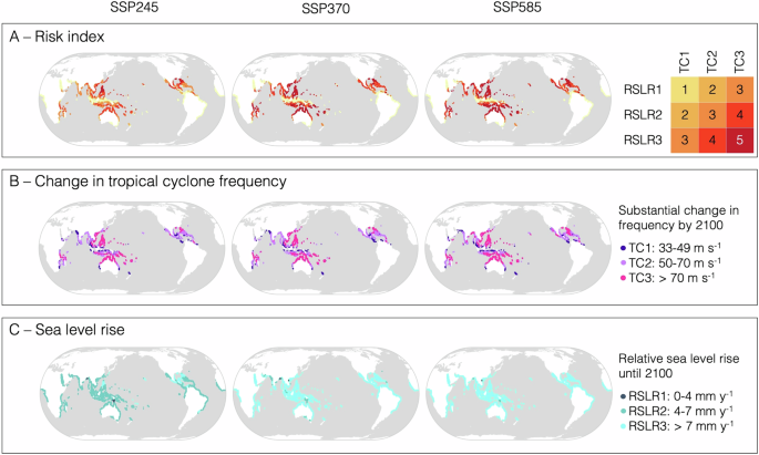
A Risk index at global mangrove locations for SSP245, 370, and 585 until 2100. The legend is the risk matrix to the right showing relative sea-level rise (RSLR) and tropical cyclone (TC) risk factors and the resulting combined risk rank. Risk ranks 1–5 correspond to low, medium, high, very high, and severe risk. RSLR1–3 correspond to the median rates of regional relative sea-level rise of 0–4 mm y-1, 4–7 mm y-1, and 7 mm y-1, while TC1-3 refer to the windspeed categories (1) 33–49 m s−1, (2) 50–70 m s−1, and (3) >70 m s−1. For further clarification on how the risk index is constructed, please see Supplementary Fig. 1. B Change in tropical cyclone (TC) frequency per intensity category for SSP245, 370, and 585 from the reference period 1995–2014 until 2100. Points are shown where the frequency at least doubles per given intensity category or if an area is newly affected by windspeeds of that intensity at least once in 250 years. C Median relative sea-level rise (RSLR) at mangrove locations for SSP245, 370, and 585 until 2100.
The probabilistic tropical cyclone data used in this study are downscaled from a statistical-dynamical tropical cyclone model23,24, which is forced by CMIP6 global climate model outputs across various SSPs for the present day and future climate. The tropical cyclone simulations over the historical period establish a baseline that realistically characterizes the current tropical cyclone disturbance regime, overcoming the limitations of the historical record of observations28. Meanwhile, tropical cyclone data for the three SSPs represents future disturbance regimes by the end of the century. Our tropical cyclone windspeed intensity categories correspond to (1) 33–49 m s-1, (2) 50–70 m s-1, (3) >70 m s-1, which are equivalent to Saffir-Simpson Hurricane Wind Scale categories 1–2, 3–4, and 5, respectively29. We consider mangroves to experience a novel disturbance regime if they are newly affected by windspeed intensities of a given intensity category, or if the relative change in frequency within the category exceeds 100% (Fig. 1B). Only windspeed intensities with return periods of up to 250 years are considered ecologically relevant and included6.
We define our sea-level rise categories as (1) 0–4 mm y-1, (2) 4–7 mm y-1, and (3) 7 mm y-1 of median regional rate of sea-level rise until the end of the century (Fig. 1C). Previous research has investigated potential thresholds in the vertical adjustment capacity of mangroves, and found deficits are likely at sea-level rise rates of 4 mm y-1, and highly likely at 7 mm y-14.
Applying this methodology, we find widespread changes in tropical cyclone frequency across all levels of windspeed intensity and high rates of sea-level rise, which put mangroves at varying levels of risk in all tropical cyclone basins (Fig. 1). Globally, depending on the SSP, we find 40–56% of mangrove area will be at high to severe risk (Table 1). A region of particular concern is Southeast Asia, where, depending on the SSP, 52–78% of current mangrove extents are at high to severe risk (Fig. 2, Supplementary Figs. 7 and 8). In Southeast Africa, Central America, and Southwest Pacific, 48–86%, 51–71%, and 17–31% of current mangrove extents, respectively, are at high to severe risk depending on the SSP (Fig. 2, Supplementary Fig. 7 and 8). Hotspots of severe risk in Southeast Asia are in the Philippines, Vietnam, Malaysia, and parts of Indonesia (Fig. 1A and Fig. 2A). Areas in the Southwest Pacific, especially northern Australia, New Caledonia and Fiji, are also at severe risk (Fig. 1A and Fig. 2A). In contrast, severe risk levels are less widespread in Central America and Southeast Africa but do occur at the east coast of Florida and the Bahamas, as well as in northern Mozambique and southern Tanzania (Fig. 1A and Fig. 2A).
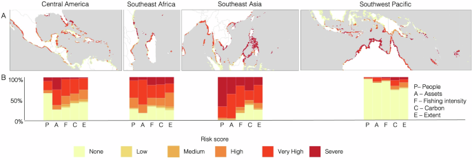
A shows the risk score for mangroves in the four hotspot areas. B shows the proportions of ecosystem services (people and assets protected, fishing intensity, and carbon storage), as well as the areal extent of mangroves, at risk across the 5 risk scores: low, medium, high, very high, and severe risk. Please see Supplementary Figs. 7 and 8 for ecosystem services at risk under SSPs 245 and 585, and Supplementary Figs. 9–20 for more highly resolved hotspot maps under SSPs 245, 370 and 585.
Global mangrove ecosystem services and biodiversity at risk
To investigate risks to ecosystem service provision, we combine our risk index with the mangrove conservation priority areas by Dabalà et al. 7, which rank global mangrove area based on mangrove species biodiversity, coastal protection for people and property, carbon sequestration, and fishery benefits. We then investigate the distribution of risk levels for mangrove areas ranked as high conservation priorities areas7, i.e., the top 10% and top 25% highest ranking areas in terms of their biodiversity, coastal protection for people and property, carbon sequestration and fishery benefits. Across all SSPs, these high-priority mangrove areas are proportionally at higher risk than mangrove areas overall (Table 1). For example, under SSP370, 13% of global mangrove area will be at severe risk by the end of the century, while for the top ranking 25% it is 2% more, and for the top ranking 10% the proportion at severe risk is almost double than that of mangroves in general (Table 1).
Zooming in on ecosystem service provision across regions, we observe distinct patterns of the areal extent and ecosystem services affected by varying degrees of risk (Fig. 2). We project Southeast Asia to be most affected, both in terms of area and ecosystem services. Under SSP370, mangroves providing 98% and 97% of coastal protection to people and properties, respectively, are projected to be at high to severe risk, while 62% of carbon and 78% fishery benefits are highly to severely threatened under SSP370 (Fig. 2, Panel B). In Central America, especially coastal protection for assets is at high to severe risk (75% for SSP370), while in Southeast Africa about half of all services are at high to severe levels of risk. The Southwest Pacific is the least affected, with carbon sequestration being the most threatened service in the region (28% for SSP370).
Further, we observe heterogeneity in terms of proportions of services at risk compared to the locations’ mangrove areal extent at risk. In all regions, the proportions of carbon sequestration and to a lesser degree also fishery benefits at a given level of risk correspond closely to the proportion of overall mangrove area (Fig. 2B). However, mangroves providing coastal protection, both for people and property tend to be at higher levels of risk in all regions than mangrove area in general, except in Central America. This heterogeneous distribution of some ecosystem services at risk in relation to mangrove area underscores the importance of mapping risk to services of interest explicitly.
Unchartered territory
Under climate change, disturbance regimes of different degrees of novelty will emerge11. We project that the frequency changes across different tropical cyclone windspeed intensities (Fig. 3) will lead global mangrove areas to be newly or more frequently affected by high (categories 3 and 4, middle row of maps in Fig. 3) and very high (category 5, bottom row of maps in Fig. 3) windspeeds. These areas include South Asia, Southeast Asia, Southeast Africa, Central America and the Caribbean. Therefore, some locations will experience future disturbance regimes that resemble the current regimes of other areas, e.g., Central American mangroves receiving high intensity winds more frequently in the future, similarly to Southeast Asian mangroves currently (Fig. 3, also see Supplementary Figs. 2 and 3). Other regions may become newly affected by tropical cyclones altogether (shown as red points in Fig. 3), e.g., mangroves at higher latitudes due to a poleward shift in tropical cyclones. Even at the lowest emission pathway, many areas across the globe, including in Central America, Southeast Africa, East Asia, and Oceania, will become newly affected by very high intensity tropical cyclone winds (Fig. 3). These projected regimes are locally novel but may be similar to historical regimes in other geographies.
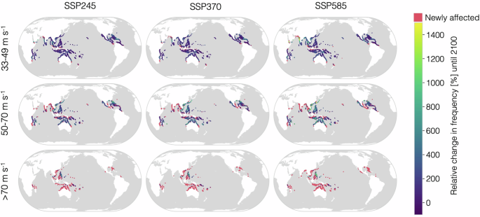
The columns of maps from left to right refer to the SSPs 245, 370, and 585, while the rows show different windspeed intensities from top to bottom, corresponding to categories 1–2, 3–4, and 5 on the Saffir-Simpson scale. For points which have previously been affected by the given windspeed intensity at least once in 250 years the relative change in frequency is shown on a continuous color scale (blue to yellow). Points which are projected to be newly affected by a given windspeed intensity at least once in 250 years by 2100 are shown in a separate color (red).
We also project that some areas will experience a non-analog future, i.e., a globally novel disturbance regime, with tropical cyclones windspeed intensities at frequencies that are currently unprecedented in the baseline. Fig 4 shows mangrove extents which are projected to experience novel tropical cyclone conditions under SSP245, 370, and 585 by the end of the century, meaning that the projected future frequency exceeds the current global maximum frequency per given intensity category. Here, Southeast Asia and especially the Philippines clearly stand out, irrespective of intensity category or SSP. Historically, the global maximum frequency of tropical cyclone windspeeds at any mangrove centroid above 70 m s-1 is 0.02 (a return period of approximately 50 years). In the east of the Philippines, however, this frequency is projected to be exceeded by up to 254% in some mangrove areas, leading to a frequency of 0.08 (a return period of 12.5 years) (Fig. 4).
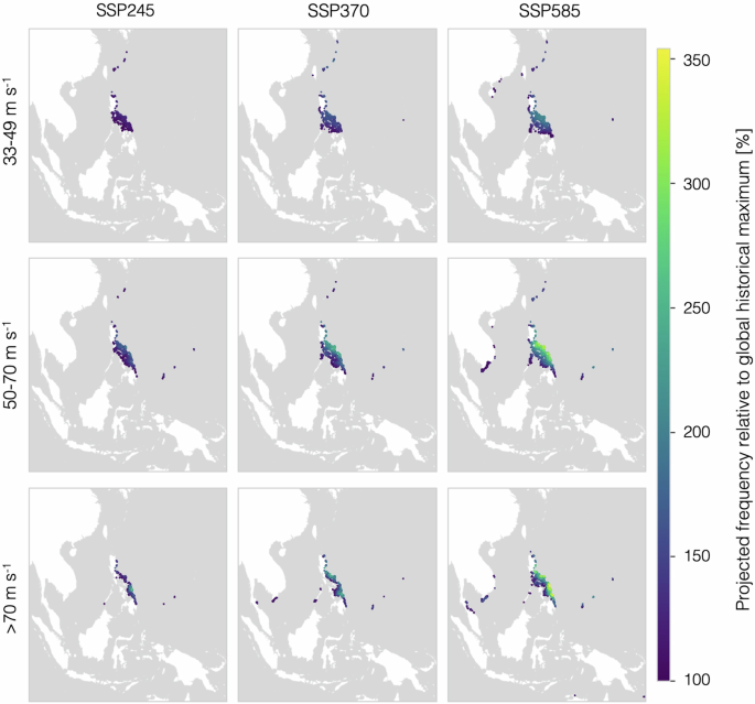
The color bar indicates the projected frequency by 2100 as a percentage of the historical global maximum frequency per intensity category, with dark colors indicating projected frequencies of up to 200% of the historical global maximum frequency and lighter colors indicating projected frequencies up 350% of the historical global maximum. Only mangrove centroids with future TC frequencies higher than the historical global maximum per intensity category are shown. The historical maximum frequencies per category are 0.45 for TC1, 0.11 for TC2 and 0.02 for TC3, which corresponds to return periods of 2.22 years, 9.43 years, and 41.92 years, respectively.
Discussion
We present the first global, spatially explicit probabilistic projection of climate-modified changes in tropical cyclone disturbance regimes in combination with sea-level rise affecting mangroves. This risk index incorporates changes in two stressors, tropical cyclones and sea-level rise, and allows connecting the risk perspective with the spatial distribution of mangroves and the services they provide. Our analysis highlights widespread risk to mangrove areas and ecosystem services under climate change globally and identifies Southeast Asia as a region of especially high concern.
Uncertainties and limitations
An improved understanding of the climate-induced changes in the tropical cyclone disturbance regime of mangrove ecosystems is vital in anticipating potential ecological responses of mangrove forests to climate change. However, the findings presented here are subject to several uncertainties and limitations. First, the choice of tropical cyclone model, as well as the global climate model (GCM) data used to drive it influences the subsequent risk assessment28,30. For instance, using GCMs with high climate sensitivity has been shown to result in higher TC risk increases under climate change30. We account for this by using median TC frequency changes based on three GCMs of varying climate sensitivities in our results. Second, the choice of the relative change in frequency threshold beyond which to consider mangroves at risk is a modeling choice which affects the risk score assigned to the mangrove area and its associated ecosystem services. Our chosen threshold of a doubling in frequency by 2100 offers a balance between considering every deviation from the baseline novel and only considering the most extreme deviations as relevant (for more detail on the threshold choice, please consult the “Methods� section). Third, a static distribution of mangrove extents and ecosystem services based on current conditions is assumed. Future research could integrate models for potential future mangrove distribution under other projected climatic changes, such as temperature and precipitation31 with the risk approach presented here.
To fully grasp novel ecological outcomes, it is not only necessary to analyze changes in the disturbance regime, but also investigate ecological responses and recovery mechanisms11. The global approach taken in this study does not allow including a variety of factors, which may greatly affect mangrove vulnerability and recovery such as mangrove forest structural properties, geomorphology, and anthropogenic disturbance32. While these factors could be included in studies aiming to mechanistically model the processes leading to ecological shifts, our approach is more suited to investigate characteristics of the changing disturbance regime and its spatial relation to mangroves and their services.
Risk hotspots for ecosystem services
The overrepresentation of service-providing mangroves in high-risk categories points to considerable societal impacts that could occur across regions due to disturbance regime shifts under climate change. In Central America our findings indicate high risk for several ecosystem services but especially coastal protection for assets. Considering the magnitude of economic benefits provided through risk reduction by mangroves in the region1,33, these ecosystem functions and recovery should be closely monitored32. In Southeast Africa all assessed ecosystem service types are at risk which is alarming given the region’s high dependence on coastal ecosystem services for their livelihoods, nutrition, and coastal protection18. We project risk to current mangrove carbon stocks in the Southwest Pacific, including Australia, where previous research indicates both losses and gains in carbon accumulation may occur depending on the climate change scenario and the level of coastal squeeze17. Our risk index can complement such research in the prioritization and monitoring of blue carbon projects in the region. Southeast Asia is the area of highest concern, both in terms of widespread severe physical risk and the share of ecosystem services affected.
According to our projections, a historically and globally novel disturbance regime may emerge in the Philippines, with tropical cyclone frequencies which are unprecedented in the baseline. Historically, the Philippines have been affected by a large share of all recorded tropical cyclone events and are exposed to storms that closely mirror the global distribution of tropical cyclones1. The country also has total mangrove extents of more than 260,000 ha (approximately 2% of global extents)1,34. Considering the frequency increases we find especially in high intensity tropical cyclone windspeeds in this area, it is uncertain in what state mangroves will be able to persist in the Philippines under unprecedented tropical cyclone frequencies across various levels of intensity. Given the relationship between tropical cyclone frequency and mangrove forest structural attributes, such as canopy height and aboveground biomass12, as well as community dynamics13, we may at least expect considerable structural changes under this unprecedented disturbance regime. Mangrove restoration may support recovery, however, restored mangrove forests are estimated to require 55 years to reach functional equivalency to their natural counterparts35. Consequently, the nature and degree of future ecosystem service provision in these areas may also be subject to considerable change.
Outlook and management implications
We project severe and widespread risk for mangrove ecosystems, especially in places currently providing high levels of ecosystem services. These estimates hint at large potential socioeconomic impacts resulting from climate-modified disturbance regime. Indeed, more than 775 million people are currently estimated to be highly dependent on coastal ecosystems18, and the number of people depending on protection by coastal ecosystems is expected to increase further under climate change36. Financially, loss of mangrove protective functions could contribute to accelerating losses under climate change, since even under current conditions mangroves provide flood protection benefits beyond US$ 65 billion annually1. Neither the loss of mangroves themselves, nor the value derived from their contributions to people is currently accounted for in Loss & Damage discussions37. Thus, there is a pressing need to further develop conceptual and modeling frameworks, as well as funding mechanisms, to capture the loss of ecosystems and their services.
Developing effective ecosystem management that is adaptive to changing disturbance regimes is imperative11,21. Our findings support this call to action, underscoring the need to adapt conservation and restoration planning to sustain ecosystem service provision under climate change and ecological transformation. In support of this goal, we map shifts in disturbance regimes and develop a risk index that can be used to identify hotspots for potential climate-induced ecological shifts. Indices such as ours can complement empirical observations of mangrove distributions and recovery failure to support conservation actors in prioritizing areas for monitoring and restoration. Taking a forward-looking perspective, our risk index can inform planning over longer time horizons as climate change occurs. For instance, our results point to the importance of considering future climate risk in the planning of blue carbon projects, especially to accurately quantify and mitigate reversal risks for nature-based blue carbon projects17. In some cases, it may also unveil untapped potential for blue carbon by identifying areas not at risk of a shifting tropical cyclone regime, but where moderate rates of sea-level rise could allow for high rates of vertical accretion and carbon capture4. Considering the higher tropical cyclone frequency and associated severity of potential impacts, however, supporting ecosystem recovery through active restoration post-event may become necessary to support mangrove forest persistence and ecosystem service provision in some areas.
Finally, this study underscores the valuable contributions of the hazard and risk modeling communities in studying emerging disturbance regimes under different levels of climate change and highlights opportunities for interdisciplinary research on the topic. Specifically, we point to investigating further dimensions of disturbance novelty such as potential changes in seasonality or duration of disturbance. The risk framework presented here can be extended to include other climate-driven hazards relevant for mangrove ecosystems, such as drought and marine heatwaves, or applied to other sets of ecosystems and disturbances. Additionally, future research could integrate ecological responses and recovery through vulnerability functions calibrated based on vegetation characteristics and hazard intensity.
Our spatially explicit risk index, which combines climate change-driven changes in tropical cyclones with sea-level rise outlines an emerging novel disturbance regime for mangroves under climate change by the end of the century. Further, our analysis highlights the importance of explicitly including ecosystem services in risk assessments, which are crucial to inform ecosystem-based climate mitigation and adaptation planning.
Methods
Tropical cyclone data
We use probabilistic tropical cyclone (TC) tracks from the MIT model23,24, downscaled from 3 different CMIP6 models of varying climate sensitivity, namely ECEarth6, CESM2, and MIROC6, and under three Shared Socioeconomic Pathways (SSPs), SSP245, SSP370, and SSP585. TC tracks were generated for the historical period (1995–2014) and by the end of the century (2081–2100). The MIT model simulates TCs using three steps: genesis, track, and intensity modeling. TC genesis is the first step, where random seeding is used to initiate warm-core vortices in space and time within a synthetic, time-evolving, large-scale atmosphere-ocean environment derived from global reanalyses or climate models, as in this study. TC frequency is a direct outcome of this random seeding process, as only a fraction of seeds in favorable conditions (e.g., warm sea surface temperatures, low vertical wind shear) survive to develop into TCs, following a natural selection algorithm23. For each simulated year, 500 synthetic TC tracks are generated, and TC frequency of each individual track ((F_i)) is calculated based on the fraction of initial seeds that develop into TCs under the given boundary conditions. This well-established approach23,24 has been demonstrated to successfully reproduce key characteristics of the observed historical TC climatology23,38. Previous research indicates modeling approaches using highly resolved CMIP models such as those used here generally project higher increases in very intense TCs than those with coarser resolutions38,39,40.
Using the CLIMADA platform41, we generate two-dimensional wind fields by applying a parametric wind model42 to each TC track at 150 arcseconds resolution (150 arcseconds corresponds to 4.63 km at the equator and 3.54 km at 40°). In detail, we compute the gridded 1-min average sustained winds at 10 meters above ground. We divide tropical cyclone windspeed intensities into three categories:
-
TC1: 33–49 m s-1
-
TC2: 50–70 m s-1
-
TC3: >70 m s-1
The expected impacts for these windspeed intensities range from defoliation and occasional stem breakage to extensive canopy loss and finally widespread mortality and peat collapse9. For each intensity category (cin) [TC1, TC2, TC3], at each grid location (x), we obtain the average annual frequency (f_x^c) by summing the frequency of all individual events (F_i) whose intensity falls within (c) (see Eq. 1).
where (delta _c_ileft(xright),c) = 1 if (c_ileft(xright)==c), else (delta _c_ileft(xright),c) = 0.
For each point in the wind field, we calculate (f_x^c) for the historical baseline ((f_hist)) and the projections ((f_fut)). Next, we calculate the absolute ((f_fut-f_hist)) and relative change in frequency (((f_fut-f_hist)/f_hist)) at the different windspeed intensities. The findings presented in the main text are based on median values of the three TC track sets based on the global climate models mentioned above. Visualizations of the return periods for the historical reference period and the three SSPs are provided in Supplementary Figs. 2 and 3, while relative changes in TC frequency per climate model can be found in the Supplementary Figs. 4–6.
Sea-level rise projections
As sea-level rise data we use the medium-confidence regional sea-level rise projections from the IPCC AR625 (https://doi.org/10.5281/zenodo.6382554), for SSP245, SSP370, and SSP585. Rates of sea-level rise are reported for different levels of probability; we use the mean of medians across all IPCC AR6 workflows. We calculate the median rate of regional relative sea-level rise (RSLR) from 2020 until 2100 at each grid point (minimum 1 degree resolution, higher at coastline gauges). The median rates are then grouped into three intensity categories (0–4 mm y-1, 4–7 mm y-1, >7 mm y-1), based on mangrove vertical adjustment capability reported by Saintilan et al.4. Vertical deficits are likely at RSLR rates beyond 4 mm y-1, and highly likely beyond 7 mm y-14:
-
RSLR1: 0–4 mm y-1
-
RSLR2: 4–7 mm y-1
-
RSLR3: >7 mm y-1
Mangrove data
We use the global mangrove extents polygons by the Global Mangrove Watch (GMW)22. The polygons are reprojected using an equal area projection (Eckert IV) to calculate their area and centroid coordinates. The resulting centroids are then matched with the tropical cyclone and regional relative sea-level rise data using the nearest-neighbor method.
Mangrove priority areas for conservation
Information on mangrove biodiversity and ecosystem services used was generated in a previous study by Dabalà et al. 7 (available from https://doi.org/10.5281/zenodo.8272951). Dabalà et al. base their assessment on three different ecosystem services, namely coastal protection for people and assets, carbon storage, and fisheries benefits. The number of people and value of properties protected is based on a study by Menéndez et al. 1. Carbon storage is estimated based on aboveground biomass43 and soil carbon26. Fishing intensity data is based on zu Ermgassen et al. 19. Dabalà et al. use a combination of mangrove biodiversity data, which they intersect with the GMW global mangrove extents22, including mangrove species data from the IUCN Red List of Threatened species44, mangrove biophysical typology45, and marine ecoregions data46. Dabalà et al. have generated a variety of optimizations; we use the priority areas optimizing for biodiversity and ecosystem services (equally weighted) regardless of existing protected areas. The priority area planning units are hexagonal polygons at a resolution of 20 km along the coastline based on the GMW mangrove distribution data7. We assign the mangrove centroids used in the TC and RSLR risk analysis to the corresponding priority area hexagon using the nearest-neighbor method.
Mangrove TC & RSLR risk index
We compile the three intensity categories for TC and RSLR into a 3 × 3 risk matrix, assigning risk scores ranging from 1 to 5, where higher scores indicate greater risk. (yielding the risk categories low, medium, high, very high, and severe). For each mangrove centroid, we calculate the risk score based on the TC and RSLR category at the given location. Here, we only consider TC windspeeds with return periods of less than 250 years to be of ecological relevance6. The TC risk criterion is considered fulfilled if a centroid is newly affected by windspeeds of the given intensity or if the frequency is projected to at least double (((f_fut-f_hist)/f_histge 1)). If this criterion is met across multiple TC intensity categories at the same centroid, the highest possible risk rank is assigned. Since we focus primarily on the shift in TC risk, we do not include areas only affected by sea-level rise in the risk index. For an illustration of how the risk index is constructed, consult Supplementary Fig. 1.
The relative change in frequency threshold beyond which to consider a centroid at risk is a modeling choice, which affects the final risk classification, and has implications for the mangrove area and ecosystem services reported to be at risk. Novelty of a disturbance regime emerges across a spectrum and can be at varying degrees of departure from the historical range of variability11. One could consider any deviation from the baseline frequency novel; however, we take a more conservative approach in setting the threshold at a 100% increase, i.e., doubling, beyond the historical baseline. Please see Supplementary Table 1 for an overview of the share of mangrove centroids above a 50%, 100%, and 200% increase in frequency. We chose the 100% threshold, since a doubling in frequency represents a clear deviation from the baseline, while also maintaining variation in terms of the share of mangrove centroids meeting this criterion across different intensity categories and SSPs.
Ecosystem service risk analysis
The results presented in Table 1 are based on the priority rank assigned to each individual mangrove centroid and the corresponding risk rank per centroid. The matching between risk score and priority unit is achieved by assigning the mangrove centroids containing the risk score information to the priority area planning units using the nearest-neighbor method, as described above. Here, we compare the risk index of the top-ranked 10% and 25% (i.e., 10th and 25th percentile priority rank, which corresponds to a rank of equal to or higher than 2 or 8, respectively) mangrove centroids to the risk index of all mangrove centroids globally. Since Dabalà et al. 7 report the absolute values of ecosystem services provided by mangroves per hexagonal planning unit, the proportions of ecosystem services at various levels of risk shown in Fig. 2B are also calculated at the level of the planning units. To obtain the risk index at the scale of the planning units rather than the individual centroids, we calculate an area-weighted mean risk index based on the areal extent and risk index values of all mangrove centroids contained in each planning unit. Despite some loss in the resolution of the risk index, we follow this approach to avoid misrepresenting the total amount of ecosystem services provided in a given area. The area-weighted risk score (R_weighted) per priority area planning unit (P) is calculated by dividing the sum of the products of each risk score (r) of mangrove centroids contained in the given planning unit and its associated area (A) with the total area of the given planning unit (Eq. 2).
This spatial overlap approach assumes a static provision of ecosystem services and does not take into account potential human responses to changes in extreme events or fluctuations in ecosystem service provision. However, it does allow identifying where areas with currently high ecosystem service provision coincide with future risk under climate change.
Non-analogous tropical cyclone frequencies
The mangroves affected by non-analogous tropical cyclone frequencies under SSP245, 370, and 585 (Fig. 4) are calculated as follows: First, we filter for all centroids where the projected future frequency ((f_fut)) exceeds the global historical maximum frequency ((f_max )) within each windspeed intensity category. Next, we calculate the change ratio ((C_nonanalog)) between the projected future frequency ((f_fut)) for the given mangrove centroid and the global historical maximum frequency ((f_max )) per windspeed intensity category:
Data availability
Global Mangrove Watch mangrove extent data is available from ref. 22. Tropical cyclone tracks were kindly provided by Kerry Emanuel based on refs. 23,24,38. Sea-level rise data is available from ref. 25. Mangrove priority areas and ecosystem data are available from ref. 7. All data47 shown in the Figures and Tables of the main text are available from Zenodo at https://doi.org/10.5281/zenodo.14869916.
Code availability
Code48 to reproduce the results of this paper is available from Zenodo at https://doi.org/10.5281/zenodo.14870133. For this study, the Python (3.9+) version of CLIMADA (3.3+) can be used41. The source code is openly and freely available under the terms of the GNU General Public License v.3.
References
-
Menéndez, P., Losada, I. J., Torres-Ortega, S., Narayan, S. & Beck, M. W. The global flood protection benefits of mangroves. Sci. Rep. 10, 4404 (2020).
-
Song, S. et al. Mangrove reforestation provides greater blue carbon benefit than afforestation for mitigating global climate change. Nat. Commun. 14, 756 (2023).
-
Mo, Y., Simard, M. & Hall, J. W. Tropical cyclone risk to global mangrove ecosystems: potential future regional shifts. Front. Ecol. Environ. 21, 269–274 (2023).
-
Saintilan, N. et al. Widespread retreat of coastal habitat is likely at warming levels above 1.5 °C. Nature 621, 112–119 (2023).
-
Schuerch, M. et al. Future response of global coastal wetlands to sea-level rise. Nature 561, 231–234 (2018).
-
Kropf, C. M., Vaterlaus, L., Bresch, D. N. & Pellissier, L. Tropical cyclone risk for global ecosystems in a changing climate. Nat. Clim. Chang. https://doi.org/10.1038/s41558-024-02194-w (2025).
-
Dabalà , A. et al. Priority areas to protect mangroves and maximise ecosystem services. Nat. Commun. 14, 5863 (2023).
-
Worthington, T. & Spalding, M. Mangrove Restoration Potential: A Global Map Highlighting a Critical Opportunity. https://doi.org/10.17863/CAM.39153 (2018).
-
Krauss, K. W. & Osland, M. J. Tropical cyclones and the organization of mangrove forests: a review. Ann. Bot. 125, 213–234 (2020).
-
Johnstone, J. F. et al. Changing disturbance regimes, ecological memory, and forest resilience. Front. Ecol. Environ. 14, 369–378 (2016).
-
Turner, M. G. & Seidl, R. Novel disturbance regimes and ecological responses. Annu. Rev. Ecol. Evol. Syst. 54, 63–83 (2023).
-
Simard, M. et al. Mangrove canopy height globally related to precipitation, temperature and cyclone frequency. Nat. Geosci. 12, 40–45 (2019).
-
Hogan, J. A. et al. The frequency of cyclonic wind storms shapes tropical forest dynamism and functional trait dispersion. Forests 9, 404 (2018).
-
Sippo, J. Z., Lovelock, C. E., Santos, I. R., Sanders, C. J. & Maher, D. T. Mangrove mortality in a changing climate: an overview. Estuar. Coast. Shelf Sci. 215, 241–249 (2018).
-
Osland, M. J. et al. A tropical cyclone-induced ecological regime shift: mangrove forest conversion to mudflat in Everglades National Park (Florida, USA). Wetlands 40, 1445–1458 (2020).
-
Chambers, L. G., Steinmuller, H. E. & Breithaupt, J. L. Toward a mechanistic understanding of “peat collapse� and its potential contribution to coastal wetland loss. Ecology 100, e02720 (2019).
-
Lovelock, C. E. & Reef, R. Variable impacts of climate change on blue carbon. One Earth 3, 195–211 (2020).
-
Selig, E. R. et al. Mapping global human dependence on marine ecosystems. Conserv. Lett. 12, e12617 (2019).
-
Zu Ermgassen, P. S. E. et al. Reprint of: fishers who rely on mangroves: Modelling and mapping the global intensity of mangrove-associated fisheries. Estuar. Coast. Shelf Sci. 248, 107159 (2021).
-
Spalding, M. D. & Leal, M. The State of the World’s Mangroves 2024. https://doi.org/10.5479/10088/119867 (2024).
-
Leverkus, A. B. et al. Environmental policies to cope with novel disturbance regimes–steps to address a world scientists’ warning to humanity. Environ. Res. Lett. 16, 021003 (2021).
-
Bunting, P. et al. The Global Mangrove Watch—a new 2010 global baseline of mangrove extent. Remote Sens 10, 1669 (2018).
-
Emanuel, K. The hurricane-climate connection. Bull. Am. Meteorol. Soc. 89, ES10–ES20 (2008).
-
Emanuel, K., Ravela, S., Vivant, E. & Risi, C. A statistical deterministic approach to hurricane risk assessment. Bull. Am. Meteorol. Soc. 87, 299–314 (2006).
-
Garner, G. G. IPCC AR6 sea level projections. Zenodo https://doi.org/10.5281/zenodo.5914710 (2021).
-
Sanderman, J. et al. A global map of mangrove forest soil carbon at 30 m spatial resolution. Environ. Res. Lett. 13, 055002 (2018).
-
Pörtner, H.-O. et al. (eds). Climate Change 2022: Impacts, Adaptation and Vulnerability. Contribution of Working Group II to the Sixth Assessment Report of the Intergovernmental Panel on Climate Change (IPCC, 2022).
-
Meiler, S. et al. Intercomparison of regional loss estimates from global synthetic tropical cyclone models. Nat. Commun. 13, 6156 (2022).
-
National Hurricane Center. Saffir-Simpson Hurricane Wind Scale. https://www.nhc.noaa.gov/aboutsshws.php (2022).
-
Meiler, S., Ciullo, A., Kropf, C. M., Emanuel, K. & Bresch, D. N. Uncertainties and sensitivities in the quantification of future tropical cyclone risk. Commun. Earth Environ. 4, 1–10 (2023).
-
Record, S., Charney, N. D., Zakaria, R. M. & Ellison, A. M. Projecting global mangrove species and community distributions under climate change. Ecosphere 4, art34 (2013).
-
Amaral, C. et al. Drivers of mangrove vulnerability and resilience to tropical cyclones in the North Atlantic Basin. Sci. Total Environ. 898, 165413 (2023).
-
Narayan, S. et al. The value of coastal wetlands for flood damage reduction in the Northeastern USA. Sci. Rep. 7, 9463 (2017).
-
Giri, C. et al. Status and distribution of mangrove forests of the world using earth observation satellite data. Glob. Ecol. Biogeogr. 20, 154–159 (2011).
-
Osland, M. J. et al. Rapid peat development beneath created, maturing mangrove forests: ecosystem changes across a 25-yr chronosequence. Ecol. Appl. 30, e02085 (2020).
-
Hülsen, S. et al. Global protection from tropical cyclones by coastal ecosystems—past, present, and under climate change. Environ. Res. Lett. 18, 124023 (2023).
-
Roe, D., Holland, E., Nisi, N., Mitchell, T. & Tasnim, T. Loss and damage finance should apply to biodiversity loss. Nat. Ecol. Evol. 7, 1336–1338 (2023).
-
Emanuel, K. Response of global tropical cyclone activity to increasing CO2: results from downscaling CMIP6 models. J. Clim. 34, 57–70 (2021).
-
Vecchi, G. A. et al. Tropical cyclone sensitivities to CO2 doubling: roles of atmospheric resolution, synoptic variability and background climate changes. Clim. Dyn. 53, 5999–6033 (2019).
-
Knutson, T. et al. Tropical Cyclones and Climate Change Assessment: Part II: projected response to anthropogenic warming. Bull. Am. Meteorol. Soc. 101, E303–E322 (2020).
-
Aznar-Siguan, G. & Bresch, D. N. CLIMADA v1: a global weather and climate risk assessment platform. Geosci. Model Dev. 12, 3085–3097 (2019).
-
Holland, G. A revised hurricane pressure–wind model. Mon. Weather Rev. 136, 3432–3445 (2008).
-
Simard, M. et al. Global mangrove distribution, aboveground biomass, and canopy height. ORNL DAAC https://doi.org/10.3334/ORNLDAAC/1665 (2019).
-
IUCN. The IUCN Red List of Threatened Species. Version 2022-12. IUCN https://www.iucnredlist.org/resources/spatial-datadownload (2022).
-
Worthington, T. A. et al. A global biophysical typology of mangroves and its relevance for ecosystem structure and deforestation. Sci. Rep. 10, 14652 (2020).
-
Spalding, M. D. et al. Marine ecoregions of the world: a bioregionalization of coastal and shelf areas. BioScience 57, 573–583 (2007).
-
Hülsen, S. Data for ‘Mangroves and their services are at risk from tropical cyclones and sea level rise under climate change’. Zenodo https://doi.org/10.5281/zenodo.14869916 (2025).
-
Hülsen, S. sarah-hlsn/mangrove_services_risk_TC_SLR: Code for ‘Mangroves and their services are at risk from tropical cyclones and sea level rise under climate change’. Zenodo https://doi.org/10.5281/zenodo.14870133 (2025).
Acknowledgements
The authors are grateful to Kerry Emanuel for providing the MIT tropical cyclone tracks data and feedback. We thank Luca Severino for comments on an early version of this manuscript. C.M.K. has received funding from the European Union’s Horizon 2020 research and innovation program grant agreement No 820712 (PROVIDE) and No 101081369 (SPARCCLE). We thank the reviewers for their insightful comments on the manuscript.
Funding
Open access funding provided by Swiss Federal Institute of Technology Zurich.
Author information
Authors and Affiliations
Contributions
S.H. conceived and designed the research, analyzed, interpreted, and curated the data, wrote the original draft, reviewed, and edited the manuscript. L.E.D. and C.M.K. contributed to the conceptualization, supervised the analysis and interpretation of data, reviewed and edited the manuscript. S.M. curated data, contributed to the analysis and interpretation of results, contributed to the writing of the original manuscript, and reviewed and edited the manuscript. D.N.B. contributed to the conceptualization, supervised the analysis and interpretation of data, reviewed and edited the manuscript, and procured funding.
Corresponding author
Ethics declarations
Competing interests
The authors declare no competing interests.
Peer review
Peer review information
Communications Earth & Environment thanks Miguel Cifuentes-Jara and the other, anonymous, reviewer(s) for their contribution to the peer review of this work. Primary Handling Editors: Claudia Zoccarato and Mengjie Wang. [A peer review file is available].
Additional information
Publisher’s note Springer Nature remains neutral with regard to jurisdictional claims in published maps and institutional affiliations.
Supplementary information
Rights and permissions
Open Access This article is licensed under a Creative Commons Attribution 4.0 International License, which permits use, sharing, adaptation, distribution and reproduction in any medium or format, as long as you give appropriate credit to the original author(s) and the source, provide a link to the Creative Commons licence, and indicate if changes were made. The images or other third party material in this article are included in the article’s Creative Commons licence, unless indicated otherwise in a credit line to the material. If material is not included in the article’s Creative Commons licence and your intended use is not permitted by statutory regulation or exceeds the permitted use, you will need to obtain permission directly from the copyright holder. To view a copy of this licence, visit http://creativecommons.org/licenses/by/4.0/.
About this article
Cite this article
Hülsen, S., Dee, L.E., Kropf, C.M. et al. Mangroves and their services are at risk from tropical cyclones and sea level rise under climate change.
Commun Earth Environ 6, 262 (2025). https://doi.org/10.1038/s43247-025-02242-z
-
Received: 30 October 2024
-
Accepted: 24 March 2025
-
Published: 05 April 2025
-
DOI: https://doi.org/10.1038/s43247-025-02242-z
Search
RECENT PRESS RELEASES
Related Post

