Understanding the environmental cap
May 2, 2025
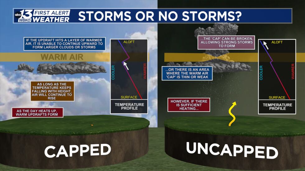
BOWLING GREEN, Ky. (WBKO) – When it comes to forecasting the chance for rain, or even the potential for thunderstorms, there’s something that weather forecasters look closely at: the cap.
This atmospheric feature can be a crucial determinant in whether storms develop throughout the day.
In a typical capped environment, the sun’s heat warms the surface, causing air and moisture to rise. Normally, temperatures cool with increasing altitude. However, if a layer of warmer air develops aloft, it acts like a lid, preventing the rising moisture and heat from reaching the levels needed for thunderstorm formation.
Conversely, an uncapped environment features a continuous cooling of temperatures with height. Without that warm layer acting as a barrier, the surface heat and moisture can continue to rise and grow, leading to the development of towering thunderstorm clouds, also known as cumulonimbus clouds.
These uncapped conditions bring the potential for various forms of severe weather, including hail, heavy rain, downpours, damaging winds, and even tornadoes.
Ultimately, the forecast for storms hinges on the temperature profile of the atmosphere. Whether the environment is capped or uncapped can make all the difference in predicting severe weather.
Copyright 2025 WBKO. All rights reserved.
Search
RECENT PRESS RELEASES
Related Post

