Victoria could see multiple days of snow this week says Environment Canada
February 16, 2026
Presented by
It might feel like spring, but snow is still in the forecast. Before winter makes a comeback, mention this article and receive 15% off any service at Galaxy Motors.
Stay ready for whatever the season throws your way.
Family Day weekend has arrived and, after weeks of mild weather, snow is back in the forecast for Victoria this coming week.
After a stretch of pleasant, almost spring-like conditions that had trees blooming and patios filling up, temperatures are set to dip across Greater Victoria in the days ahead.
So before you fully commit to spring mode, you may want to keep that snow shovel within reach.
According to the latest forecast from Environment Canada, Victoria could see multiple days of unsettled weather starting Monday, with daytime highs in the lower to mid-single digits and overnight lows dropping to zero degrees or below in inland areas.
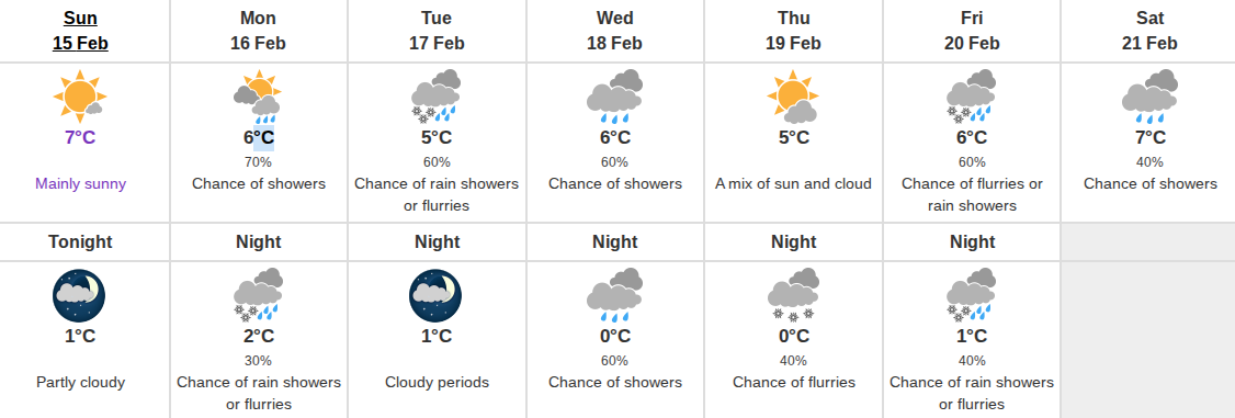
Today (Sunday) is expected to be mainly sunny with a high of 7°C before increasing cloudiness moves in tonight and temperatures fall to around 1°C, slightly milder near the water.
Monday is shaping up to be mainly cloudy with a 70% chance of showers developing late in the morning and a high of 6°C. By Monday night, there is a 30% chance of rain showers or flurries with a low near 2°C.
Tuesday brings a 60% chance of rain showers or flurries and a high of 5°C Overnight, cloudy periods are expected with a low of 1°C.
Wednesday looks similar, with a 60% chance of showers and a high of 6°C. Temperatures are forecast to dip to zero overnight.
Thursday offers a brief break with a mix of sun and cloud and a high of 5°C, though there is a 40% chance of flurries Thursday night as temperatures again fall to zero.
By Friday, there is a 60% chance of flurries or rain showers with a high of 6°C, followed by a 40% chance of rain showers or flurries overnight. Saturday currently shows a 40% chance of showers and a high of 7°C.
With cold overnight lows and precipitation in the forecast, that combination could mean snow, particularly in inland and higher terrain areas of Greater Victoria. Long-range models are indicating the potential for cumulative snowfall totals of 10 centimetres or more in some inland spots, though it is still too early to pinpoint exact amounts.
Heavier accumulations are expected further from the coast and north of the city, so those planning travel into the Island’s interior should keep a close eye on conditions. Winter or snow-rated tires remain mandatory for travel across the Malahat and west of Sooke until April 1st.
For now, it is a reminder that while blossoms may be popping up around town, winter has not quite finished with Victoria just yet.
Search
RECENT PRESS RELEASES
Related Post


